Douglas-Apsley National Park – Sat. 10th April 2021
The east coast of Tasmania has many coastal delights, along with several wilderness parks and reserves. Just north of the bustling holiday resort of Bicheno is the eastern boundary of the Douglas-Apsley National Park. Quite different from its western and alpine counterparts, it nevertheless offers wilderness and solitude among the dry sclerophyll forest, and walks along the beautiful and spectacular Apsley and Douglas River gorges.
Walk Route:
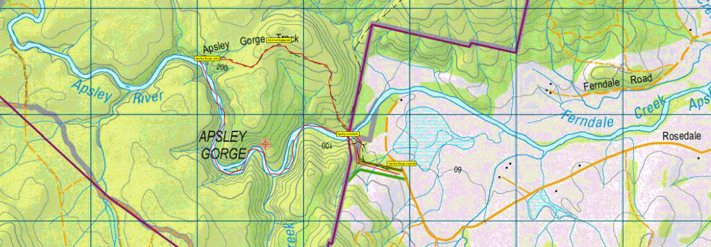
Weather and conditions permitting, Terry hopes to complete the Apsley River Gorge circuit, which includes return via the river bed. This would depend on a dry day and relatively low river levels. Sturdy shoes are necessary as some sections of the river bed require careful scrambling and plenty of boulder hopping. Distances are not huge - just under 3 km up the track to the beginning of the gorge descent, and 6.5 km altogether from the car park. It's not a flat walk! 150 metres altitude is gained over about 1 km before dropping 60 metres to enter the gorge. The route passes imposing dolerite cliffs and some lovely low waterfalls, and in warmer weather, the waterhole near the carpark end of the walk is ideal for a swim - perhaps even in April! The walk would suit moderately fit adults and energetic and resilient children who are don't mind the rocky, off-track experience.
If conditions on the day are unsuitable, the return will be by the main trail, which makes it a quicker and easier trip, and Terry would likely then take you for a stroll on Denison Beach to the Porch Rocks to complete the day. A more detailed outline of the walk can be found at Apsley River Gorge – TasTrails.com
Meeting Times and Places:
If you are interested in going on this walk, please phone your walk leader, Terry Heier, ph. 6393 6671 to book in. The departure time is 7:30 am from the Door of Hope Church car park, Launceston. If you would like to arrange to meet the group elsewhere, please arrange with the leader, and please be at any meeting place 5 minutes ahead of the listed time. The leader should always be notified of any other people you intend to bring along, and you should always contact the walk leader if intending to participate in a particular Boots N’ All walk.
To access this area from northern Tasmania: From Launceston, follow the southern outlet and Midland Highway for 70 km to Campbell Town and continue across the Red Bridge to the junction of the Lake Leake Highway (B34) near the southern outskirts of the town. Turn left and follow B34 for 60 km right through to the Tasman Highway (A3) junction. Turn left and head north and then north-east along the Tasman Highway 33 km to reach Bicheno. Continue northwest along Tasman Highway for 4.5 km to reach Rosedale Rd. Follow Rosedale Rd. 7.3 km west to reach the Apsley Gorge carpark . Total distance 177 km from Launceston, and allow 2 hours 10 minutes drive time. There are alternative routes through the Fingal Valley via St. Mary's, or via Royal George and the Old Coach Road (gravel) but these would take longer.
Warnings:
The following codes [from our 2021 walks calendar] apply:
S Steep incline for at least part of the way
B Boulders (in gorge section) – walkers need to be able to confidently step from rock to rock
D Drive distance requires early departure
Please take note of the weather forecast on the day. Make sure you bring drinking water – we suggest 1 litre per person. Walkers are advised to wear sturdy boots or strong, high sided sneakers. You should always carry wet weather gear as well as warm clothing in case of sudden weather changes.
Follow this link for further information on clothing suggestions for exposed conditions.
Click this link for a more detailed discussion of Preparation, Food and Safety guidelines for Boots N’ All walks.
Map details and references:
For the Apsley Gorge area, 1:100000 map is Break O'day (Tasmap 8514) and 1:25000 map is Henry (TasMap 5836)
Short ref. n/a
Latitude Longitude
-41.865332, 148.191920
There are no peakbagger points associated with this walk. For listing of peakbagger points, see the Hobart Walking Club Peakbagger’s Guide (2000 revision) which can be found and downloaded (as an Excel spreadsheet) from http://tastracks.webs.com/peakbaggers.htm The same web page contains several other listings of Tasmanian peaks.
For GPX (.gpx) and Google Earth (.kml) versions of the track: Click here to browse our collection.
Direct links: GPX for this walk …. KML for this walk
