Rocky Cape Circuit – Sat. 24th August 2024
THIS WALK WAS CANCELLED DUE TO POOR WEATHER FORECAST. WE WILL AIM TO RE-SCHEDULE FOR JAN. OR FEB. 2025
It’s 19 years since Boots N’ All last organised a walk to Rocky Cape, so it’s high time we return to take advantage of the spectacular coastal scenery and precious aboriginal heritage of this national park. There are various walks – shorter and longer – at Rocky Cape, but we will be following a fairly long circuit that visits the coastline for some of the distance, and then takes us inland to traverse part of Sisters Hills, where we will have panoramic views.
Walk route:
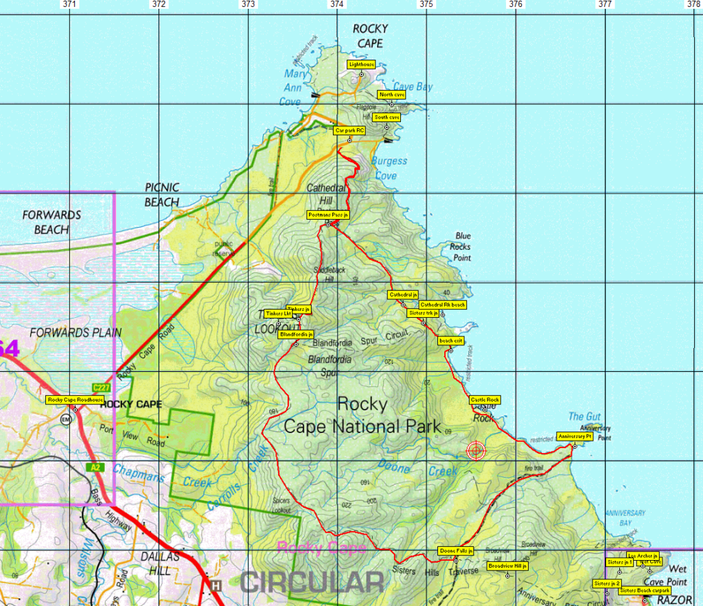
Mark Lawrie will guide us in a visit to North and South Caves (aboriginal heritage sites) and the lighthouse before we set off on the Postmans Track, skirting south around Cathedral Hill for 1 km before heading southeast for about 2 km to reach the coast. Another 2 km takes us further southeast along the coast, past the spectacular Castle Rock to Anniversary Point. We then head inland for about 1.5 km to reach the skyline of the Sisters Hills traverse, following west and then northwest for about 5 km to reach Tinkers Lookout, alt. 294m, the high point of the walk. Finally, we continue north for about 1.5 km to rejoin our outward track at Postmans Pass, and about 1 km back to the start. While the walking is quite easy, the distances (just under 15 km for the main walk) suggest a reasonable level of fitness is needed to keep up a good walking pace. Energetic and resilient children should be able to manage the walk.
Meeting Times and Places:
If you are interested in joining this walk, please phone or text Mark Lawrie on 0418 527 525 or Grace Hillman, on 0490 840 866 to book in.
If starting from Launceston, the departure time is 7:30 am from Door of Hope carpark in South Launceston.
If you are from the northwest, please meet Mark at the Rocky Cape roadhouse (at Bass Highway junction of Rocky Cape Rd.) at 9.40 am.
If you would like to arrange to meet elsewhere, please arrange with the leader, and please be at any meeting place 5 minutes ahead of the listed time. The leader must be notified of any other people you intend to bring along.
To access this area from northern and northwest Tasmania:
From Launceston, follow the Bass Highway (A2) to Burnie. Continue northwest for another 49 km from Burnie to reach the meeting place – the roadhouse at junction of Rocky Cape Rd (C227) Total distance from Launceston to Rocky Cape roadhouse 194 km (allow 2 hours 10 min).
For northwest people – much the same but way shorter! See above for directions from Burnie.
From the roadhouse, it is approximately 5 km northeast to the general area of the lighthouse, caves and start-finish of the walk.
Warnings:
L A long day’s walk – close to 4 hours at a reasonable pace.
S The grades will mostly be gradual, but there will be steep pinches to reach the higher sections.
You should carry wet weather gear as well as warm clothing in case of sudden weather changes. Walkers should carry plenty of water with them – we suggest at least 1 litre. Also bring your lunch and snacks. Sturdy high-sided sneakers or walking boots recommended. No real need for gaiters, but some will still prefer to wear them.
For equipment and safety guidelines, Click Here.
Map details:
Rocky Cape 1:100000 map is Circular Head (TasMap 7916) and Inglis (8015) and 1:25000 map is Rocky Cape (TasMap 3647).
Map reference: Rocky Cape
Short ref. n/a
Zone Easting Northing Latitude Longitude
55G 3 73 339 54 73 537 -40.52767 145.29803
No peakbagger points will be visited on this trip. To find out about these, see The Peakbaggers Points List, which can be downloaded (Excel) from http://tastracks.webs.com/peakbaggers.htm which contains the 1983 and 2000 versions, developed from the original 1968 Hobart Walking Club version. A parallel and more recent but not identical list system is The Abels – also available on the same website, which also contains some other listings of Tasmanian peaks.
For GPX (.gpx) and Google Earth (.kml) versions of the track: Click here to browse our collection.
Direct links: GPX for this walk : KML for this walk.
Right-click on the file and save target as to a location of your choice. (Suggest you click the Last modified at top to sort by date to get the most recent at top to find the file for the next walk).