
Mt Victoria Sat. 21st September 2024
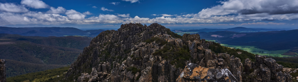
Mt. Victoria is a prominent peak in the north-east with panoramic views to north and east coasts. A relatively short walk of under 6 km return, the track climbs steadily from 800m through varying forest and on to open boulder fields before traversing the summit ridge to the peak at 1213m from which there are expansive views of the north-east, including part of Bass Strait and the east coast. The walk does involve some rock-hopping across boulder fields, and a few people have been troubled by the exposed rocky sections near the summit, but it is otherwise not difficult, and energetic children have found it quite achievable in the past. There are a couple of scrubby patches, and depending on the level of track maintenance, wearing shorts might result in scratched legs.
Walk route:
From the car park at Mt. Albert Rd, the track climbs to the NE for nearly 2 km, before swinging east and then slightly south to the summit. 2 hours walk should be sufficient to reach the summit, with a similar return time, along with time to rest, eat lunch and enjoy the views.
Meeting Times and Places:
If you are interested in going on this walk, please phone or text Benjamin Filleul on 0422 741 569. The departure time is 8:00am from Door of Hope carpark in South Launceston. The alternative meeting place/time is at Myrtle Park gates at 8:20 am, or at the Mt. Victoria car park at 9:30 am. However, you still need to contact the walk leader per details above if intending to walk. The leader should be notified of any other people you intend to bring along. Please be at any meeting place 5 minutes ahead of departure time.
To access this area from northern Tasmania:
Proceed from Launceston along the Tasman Hwy through Waverley and continue 33 km to reach the Myrtle Park picnic ground gate. Continue a further 500 metres and turn right into Camden Hill Rd. After approx. 6.5 km, turn left into Diddleum Rd, and after a further 2.5 km, take the right turn, staying on Diddleum Rd for a further 10 km to the junction of Ben Ridge Rd. Continue east for about 24 km to reach the junction of Mathinna Plains Rd. and turn right. After about 2 km, turn left into Mt. Albert Rd.
Warnings: [from our 2024 walks calendar]
S Steep incline for at least part of the way
B Boulder field – walkers need to be able to confidently step from rock to rock.
E Exposed alpine conditions – can be dangerous in poor weather if not fully equipped
Make sure you have a good supply of drinking water – suggest 1 litre per person.
Walkers are advised to wear strong shoes or boots. You should always carry wet weather gear as well as warm clothing in case of sudden weather changes.
Click this link for a more detailed discussion of Preparation, Food and Safety guidelines for Boots N’ All walks, and especially preparation for exposed alpine conditions.
Map details: Mt. Victoria: 1:100000 map is Tasmap 8415 (Forester) and 1:25000 map is 5642 (Victoria)
Map reference:
Short ref. 702237
Zone Easting Northing Latitude Longitude
55G 5 70 340 54 23 935 -41.33300 147.84061
Mt. Victoria is worth 2 peakbagger points. See The Peakbaggers Points List, which can be downloaded (Excel) from http://tastracks.webs.com/peakbaggers.htm which contains the 1983 and 2000 versions, developed from the original 1968 Hobart Walking Club version. A parallel and more recent but not identical list system is The Abels – also available on the same website, which also contains some other listings of Tasmanian peaks.
For GPX (.gpx) and Google Earth (.kml) versions of the track: Click here to browse our collection.
Direct links: GPX for this walk KML for this walk
Right-click on the file and save target as to a location of your choice. (Suggest you click the Last modified at top to sort by date to get the most recent at top to find the file for the next walk).
