Lake Lucy Long 28th December 2024
Having made two cold season attempts to put on this walk, both cancelled due to plateau closure for deer-culling, we have instead chosen to use it as our customary post-Christmas walk “to work off that Christmas cheer”. Note – this was originally listed for Friday 27th December, but will now be on Saturday 28th.
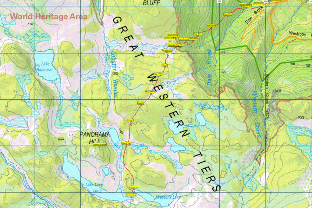
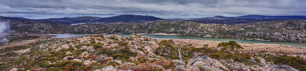
Unlike the intended winter date, we can hope for warm sunny weather on the plateau, with expansive views, There should be a great showing of wildflowers of various kinds, and hopefully the scoparia will still be in full colour. Lake Lucy Long, and Westons Lake, less than 100 metres away, are reached after climbing Higgs Track, past Lady Lake (well known for its comfortable hut), and then south into a land of lakes and peaks and areas of open alpine vegetation. Sights should include Panorama Hill, Lake Lucy Long and Lake Weston with views east to Mt. Ironstone and south to Forty Lakes Peak.
Walk Route:
The climb from the car park to Lady Lake rises 500 metres over about 2 km on a well-formed but steep track. Heading south past Lady Lake Hut, the track rises a further 90m over the next km or so before levelling out at about 1200 metres for the continuation south towards Lake Nameless. 3.5 km from Lady Lake hut will bring you to Lakes Lucy Long and Weston on either side of the track. Lunch will likely be on the grassy shores of Westons Lake before ascending a ridge above Lake Lucy Long to gain views across the plateau. Return by the same route. While the walk is rated medium, it does require considerable effort for the initial climb, and should only be attempted by well-equipped, fit and energetic walkers who are familiar with alpine track conditions. Total distance is about 13 km return. Resilient and energetic older children should cope well with this walk. Even in high summer, walkers must be fully prepared for poor weather. Please see the warnings below.
Meeting Times and Places:
If you are interested in going on this walk, please phone your walk leader, John Tabor, ph. 0475 566 389 to book in. The departure time is 8:00 am from the Door of Hope Church car park, Launceston. Suggested meeting places if coming from elsewhere are at the Deloraine train park at 8:35 am or Dale Brook Rd. turnoff at 9:00 am. If you would like to arrange to meet the group at these places or elsewhere, please arrange with the leader, and please be at any meeting place 5 minutes ahead of the listed time. The leader must be notified of any other people you intend to bring along.
To access this area from northern Tasmania: From Launceston, proceed along the Bass Highway to Deloraine (about 51 km). Follow the off-ramp into Deloraine and when crossing the bridge, turn right at roundabout to enter the ‘train park’ car park. (If you were not meeting the group there, you would not turn off at the eastern exit into Deloraine. Instead, continue across Meander R. and uphill to the western exit, and to the roundabout at start of Mole Creek Rd.) After leaving the train park, follow the main street uphill through Deloraine to reach the large roundabout. Turn left into Mole Creek Rd. and go about 8 km before turning left into Dairy Plains Rd. Go all the way through Dairy Plains Rd. (several right hand turns and 2 junctions where you need to follow the signs). When you arrive at the T-junction with Western Creek Rd, turn right and 800m further on, turn left up Westrope Rd. Go more or less straight for 4 km south, to reach the junction of Dale Brook Rd. which turns off to the right. The car park for the walk is about 500 metres from Westrope Rd. Westrope Rd. is all gravel, and somewhat degraded in parts, but should be accessible for 2WD vehicles with reasonable clearance.
Warnings:
The following codes [from our 2024 walks calendar] apply:
M Marshy or muddy sections – be prepared to walk with wet feet.
S Steep incline for at least part of the way
E Exposed alpine conditions ; can be dangerous in poor weather if not adequately equipped.
Click this link for a more detailed discussion of Preparation, Food and Safety guidelines for Boots N’ All walks.
Map details:
Western Creek/Higgs Track area: 1:100000 map is Mersey (Tasmap 8114) and 1:25000 map for the area is Lake Mackenzie (TasMap 4438).
Map reference: (eastern end of Lake Lucy Long)
Short ref. n/a
Zone Easting Northing Latitude Longitude
55G ….. 4 53 092 ….. 53 82 888 ….. -42.2644 ….. 46.26172
No peakbagger points will be visited on this trip. To find out about these, see The Peakbaggers Points List, which can be downloaded (Excel) from http://tastracks.webs.com/peakbaggers.htm which contains the 1983 and 2000 versions, developed from the original 1968 Hobart Walking Club version. A parallel and more recent but not identical list system is The Abels – also available on the same website, which also contains some other listings of Tasmanian peaks.
GPX version of the track: Right-click here to download. Google Earth version of the track: Click here to open in Google Earth [if available on your device].
Click here to browse our entire collection of walk tracks, including to find GPX (.gpx) and Google Earth (.kml) versions of the track for this walk.
Click here to learn about using your phone as a navigation device, or to find out about handheld GPS devices.