Maria Island 8th – 10th June 2024
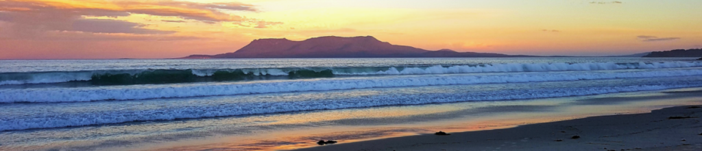
Maria Island is located on the east coast and is full of heritage, including surviving convict buildings, as well as spectacular landscapes, providing both ocean and mountain views.
This weekend is going to be a “Choose your own Adventure” style. There are multiple walk options on Maria Island, spanning from short heritage trails, through to full day walks up a mountain peak, and you can walk as many as you like, or even spend the weekend reading a book on the beach! For more information on what is on offer on Maria, head to the PWS website: https://parks.tas.gov.au/explore-our-parks/maria-island-national-park
The flexible activity arrangements and the great facilities make this trip suitable for families with young children who don’t mind camping in tents.
There is a ferry crossing from Triabunna across to Maria Island. We will be camping at the Darlington campground, where there is a camp kitchen (with BBQs and gas cooktops), toilets and rainwater. There is an approximately 500m walk from the ferry to the campground, however, there are trolleys for all the gear, so it allows for heavier items (larger tents, eskys etc) to be brought if desired.
**** If you would like to come for this weekend, you must book your own ferry trip.
The ferry costs $64 per adult and $39 per child return and can be booked here: https://encountermaria.com.au/timetable-pricing-luggage-check/ . We will plan to take the 11.30am ferry on the 8th from Triabunna and the 2.30pm ferry on the 10th from Maria Island. However, these times are flexible if they are not suitable.
The campground costs approximately $7pp per night (slight variation depending on number of people per tent) and is paid for at the Triabunna Visitor Centre before boarding the ferry. Further information can be found here: https://parks.tas.gov.au/explore-our-parks/maria-island-national-park/maria-island-camping-darlington
Gear list to bring: cooking equipment (pots/pans, utensils), crockery and cutlery, food (there is no fridge, but eskys are often sufficient for a couple of days), camping equipment (tent, sleeping mat, sleeping bag, pillow).
Meeting Times and Places:
If you are interested in going on this walk, please phone Hannah Waterhouse on 0427 026 233 to book in, preferably by Tuesday 4th June, but if you are thinking of coming, Hannah would be happy to discuss with you even earlier, to help sort out car pooling, tent sharing etc. The departure time is 8am from Door of Hope carpark in South Launceston. Additional meeting points can be arranged if needed. The leader should be notified of any other people you intend to bring along. Please be at any meeting place 10 minutes ahead of departure time.
Important! Online Registration required! Click here to register. 2024 SU safety regulations require completion of an online registration form for all Boots N’ All overnight camping trips.
To access this area from northern Tasmania: From Launceston, follow the southern outlet and Midland Highway for 70 km to Campbell Town and continue across the Red Bridge to the junction of the Lake Leake Highway (B34) near the southern outskirts of the town. Turn left and follow B34 for 60 km right through to the Tasman Highway (A3) junction. Turn right and continue south for 10km to reach Swansea, and continue to follow Tasman Highway south for another 49 km to reach Triabunna. Allow 2 hours 10 minutes (plus any breaks) from Launceston. Signs will hopefully direct you to the ferry berth.
Warnings:
The following codes [from our 2024 walks calendar] apply:
S Steep incline for at least part of the way [if you choose to climb mountains!]
Walkers should wear sturdy footwear due to uneven surfaces. Carry plenty of water and a snack if heading for the peaks. You should always carry wet weather gear as well as warm clothing in case of sudden weather changes. For equipment guidelines, CLICK HERE.
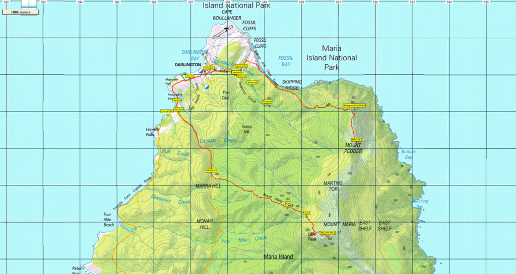
Map details:
Mt Maria: 1:100000 map is Nugent (8412) [also older 8512] and 1:25000 map is Darlington (5828).
Map reference: 805909
Zone Easting Northing Latitude Longitude
55G ~~5 90 710 ~ 52 80 610 ~ -42.62161 ~ 148.10612
Bishop & Clerk: 1:100000 map is Nugent (8412) [also older 8512] and 1:25000 map is Darlington (5828).
Map reference: 913834
Zone Easting Northing Latitude Longitude
55G ~~~ 5 91 430 ~52 84 070 ~ -42.59037 ~ 148.11435
Mt. Maria is worth 2 peakbagger points, and Bishop & Clark is 1 point. To find out about these, see The Peakbaggers Points List, which can be downloaded (Excel) from http://tastracks.webs.com/peakbaggers.htm which contains the 1983 and 2000 versions, developed from the original 1968 Hobart Walking Club version. A parallel and more recent but not identical list system is The Abels – also available on the same website, which also contains some other listings of Tasmanian peaks.
For GPX (.gpx) and Google Earth (.kml) versions of the track: Click here to browse our collection.
Direct links: GPX for this walk … KML for this walk
Right-click on the file and save target as to a location of your choice. (Suggest you click the Last modified at top to sort by date to get the most recent at top to find the file for the next walk).