Minnow Falls at Mt. Roland Sat. 7th September 2024
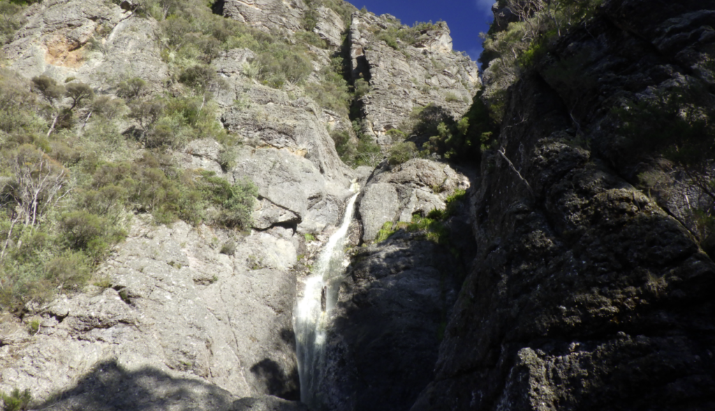
The last Boots N’ All walk to Minnow Falls was in 2009, so here’s your chance to visit these very impressive walls on the east face of the Mt. Roland massif. There are 3 main falls, dropping over 200 metres altogether. It isn’t a particularly long walk up to the falls – under 3 km all the way to the top, but there are some steep climbs, including a sections of rope ladder, and a cave that needs to be scrambled through. If the group is particularly energetic, your leader may take you all the way up to the escarpment, following around to the south and descending steeply down a ridge. Even then, the walk is just under 7 km, but the descent is very rugged in places. Energetic and adventurous older children would enjoy the walk to the falls.
Meeting Times and Places:
If interested in going on this walk, please phone or text your walk leader, Kent Lillico on 0428 451 528 to book in. The departure time is 8:00 am from Launceston, with Kent meeting the party at the Mole Creek toilet block at 8:50 am.
If you would like to arrange to meet the group at these places or elsewhere, please arrange with the leader, and please be at any meeting place 5 minutes ahead of the listed time. The leader should always be notified of any other people you intend to bring along, and you should always contact the walk leader if intending to participate in a particular Boots N’ All walk.
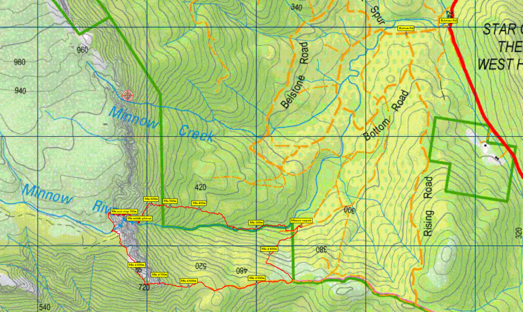
To access this area from northern Tasmania: proceed along the Bass Highway to Deloraine (about 51 km), but do not turn off at the eastern exit into Deloraine. Instead, continue across Meander R. and uphill to the western exit, and to the roundabout at start of Mole Creek Rd. A further 24km will bring you to Mole Creek. Continue a further 4km past Mole Creek, on what is now Liena Rd, and take the right exit at the caravan park into Union Bridge Rd. (C137). Follow northwest, then north, across the Mersey R. and through some hilly and winding sections for 12 km to reach Belstone Rd. Turn left and about 400m in, turn left again into Rising Rd, then after a further 300m take the right fork into Bottom Rd. Follow this road for just under 2km to reach the Minnow Falls carpark.
It is also possible to reach Belstone Rd coming from the northwest via Sheffield. From Sheffield, follow Claude Rd. (C137) south for 4 km and turn left into Paradise Rd (C137). Continue for 7.5km to reach Belstone Rd on your right.
Warnings:
The following codes [from our 2024 walks calendar] apply:
S Steep incline for at least part of the way
E Exposed alpine conditions; can be dangerous in poor weather if not adequately equipped.
Walkers are advised to wear strong shoes or boots. You should always carry wet weather gear as well as warm clothing including gloves and beanies in case of sudden weather changes. The destination of this walk is above 1000 metres altitude, and can be very exposed if the weather turns bad. Be prepared!
Bushwalking in early spring can be dangerous in poor weather if not adequately equipped; For equipment and safety guidelines, Click Here.
Map details for Minnow Falls area:
1:100000 map is Forth (Tasmap 8115) and 1:25000 map is Cethana (Tasmap 4440)
Map references:
Short ref. n/a
Zone Easting Northing Latitude Longitude
55G 4 41 930 54 07 200 -41.29082 146.18264
No peakbagger points will be visited on this walk. See The Peakbaggers Points List, which can be downloaded (Excel) from http://tastracks.webs.com/peakbaggers.htm which contains the 1983 and 2000 versions, developed from the original 1968 Hobart Walking Club version. A parallel and more recent but not identical list system is The Abels – also available on the same website, which also contains some other listings of Tasmanian peaks.
For GPX (.gpx) and Google Earth (.kml) versions of the track: Click here to browse our collection.
Direct links: GPX for this walk … KML for this walk
Right-click on the file and save target as to a location of your choice. (Suggest you click the Last modified at top to sort by date to get the most recent at top to find the file for the next walk).