Mt Barrow South – Sat. 5th October 2024
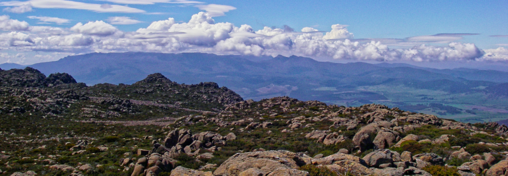
Despite it being so close to Launceston (less than 1 hour to the escarpment carpark), it has been 15 years since Boots N’ All explored the high parts of Mt. Barrow. Back then, it was promoted by leader John Potts as the “Walk of Orange Wombats” because he noted that the local fauna seemed to have developed a peculiar colour on this compact alpine plateau. At an average 1300 metres altitude, the car will have already done the hard work, and the walking is relatively flat, with 2-3 rocky outcrops that will not need much exertion.
Walk details:
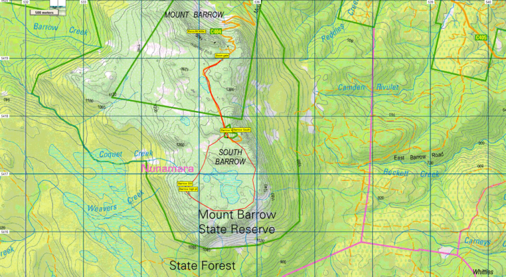
The walk begins at the boom gate close to the top of the ascent, and follows the dirt road southeast, then south for about 1.5km to the general area of the television towers. From there, the open alpine plateau is followed southwest for a further 1 km to reach a southwest high point, offering views towards Launceston and the south. We will then head east, skirting the southern end of the plateau and exploring some of the viewpoints, before following the eastern escarpment north to rejoin the road near the TV towers. This part of the walk will be about 2.5 km, but a shorter route might be followed to avoid boulder fields. The road will then be followed for 1.5 km to return to the cars. Total distance will be about 7 km.
Mt. Barrow summit is not included in this walk, but peakbaggers and Abel chasers will have time to add it as an extra – less than 1 km from carpark, and a steep 100 metres gain in altitude, and another peakbagger point (or Abel) is yours for the taking!
Meeting Times and Places:
If you are interested in going on this walk, please phone Basil Tkaczuk on 6331 1155
or email by Thursday night to book in (reply to the reminder email). The departure time is 9:30am from Door of Hope carpark in South Launceston. The alternative meeting place is at the junction of Mt. Barrow Rd at 10 am, or carpark at top of Mt. Barrow at 10:30 am. If you would like to arrange to meet the group at these places or elsewhere, please arrange with the leader, and please be at any meeting place 5 minutes ahead of the listed time. The leader should always be notified of any other people you intend to bring along, and you should always contact the walk leader if intending to participate in a particular Boots N’ All walk.
To access this area from northern Tasmania:
From Launceston, proceed along the Tasman Hwy through Waverley and continue 29 km to reach Mt. Barrow Rd, C404 on right. A further 14km of gravel road, the final 2-3 km is very steep, narrow and precarious, so drive with great caution. There is a carpark at the top of the road. It may be possible to park closer to the boom gate.
Warnings:
E… Exposed alpine conditions – can be dangerous in poor weather if not fully equipped
Make sure you have a good supply of drinking water – suggest 1 litre per person.
Walkers are advised to wear strong shoes or boots. As a large part of this walk is off track, though mostly low alpine vegetation, gaiters may add to comfort. You should always carry wet weather gear as well as warm clothing in case of sudden weather changes.
For equipment and safety guidelines, Click Here.
Map details: Mt. Barrow: 1:100000 map is Tasmap 8315 (Pipers) and 1:25000 map is 5241 (Nunamara)
Map reference:
Short ref. 350192 (summit – not the destination of this walk)
Zone Easting Northing Latitude Longitude
55G 5 35 720 54 17 680 -41.39162 147.42726 (South Barrow)
Mt. Barrow (summit – not the destination of this walk) is worth 1 peakbagger point. See The Peakbaggers Points List, which can be downloaded (Excel) from http://tastracks.webs.com/peakbaggers.htm which contains the 1983 and 2000 versions, developed from the original 1968 Hobart Walking Club version. A parallel and more recent but not identical list system is The Abels – also available on the same website, which also contains some other listings of Tasmanian peaks.
For GPX (.gpx) and Google Earth (.kml) versions of the track: Click here to browse our collection.
Direct links: GPX for this walk ¦ KML for this walk
Right-click on the file and save target as to a location of your choice. (Suggest you click the Last modified at top to sort by date to get the most recent at top to find the file for the next walk).