Mt. Pillinger Sat. 23rd November 2024
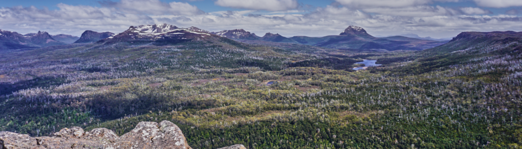
Mt. Pillinger is situated near the Arm River track, one of the popular access routes to the Mt. Ossa and Pelion Plains area. It is a beautiful alpine area high above Lee’s Paddocks, with views to the Pelions and Mt. Ossa, just under 10 km to the southwest. The walk offers the opportunity to experience the heart of the Overland Track wilderness on a day walk.
Walk Route:
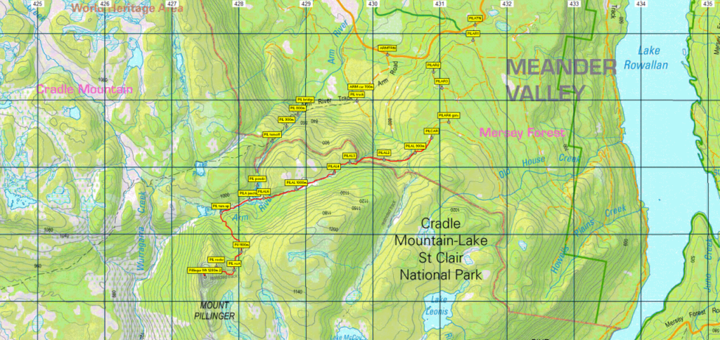
There are two routes which our leader will choose from, depending on road conditions. Both are a similar distance, just under 6 km each way. The more familar Arm River track is better marked but starts about 700 metres altitude, whereas Maggs Track, not officially maintained as a track, makes the walk a little easier by starting close to the 900 metre contour, and these days affords a slightly shorter drive.
Maggs Track starts with a fairly flat km before a short rise to 1000 m altitude and a further 2 km of relatively flat walking. During this stretch, it joins up with a side track from the Arm River track (which the leader may still decide to use) in an open alpine valley. Turning south, the route track enters forest and becomes more rocky, climbing steadily over the next km to gain a further 100 metres altitude followed by a few hundred metres of more gentle grade before the steep climb to the summit commences, rising nearly 200 metres over the next half km. The summit ridge is notable for cliffs on its western side, and on a clear day, the views are breathtaking. The steep inclines and rough track indicate this walk should be considered medium-hard and suited for more experienced alpine walkers. This could include fit and energetic children who are used to the conditions.
Meeting Times and Places:
If you are interested in going on this walk, please phone Nik Sands on 0429 387 777 to book in. The departure time is 7:00 am from Door of Hope car park. If you wish to meet with the group at any other place, please arrange with the leader. Please be at any meeting place 5 minutes ahead of departure time.
The leader should always be notified of any other people you intend to bring along, and you should always contact the walk leader if intending to participate in a particular Boots N’ All walk.
To access the area from Launceston, proceed along the Bass Highway to Deloraine (about 51 km), but do not turn off at the eastern exit into Deloraine. Instead, continue across Meander R. and up hill to the western exit, and to the roundabout at start of Mole Creek Rd. A further 24km will bring you to Mole Creek (sometimes used as a meeting place for our walks – check with leader). Continue west past Mole Creek, on what is now Liena Rd, making sure you turn south at the caravan park 4 km from the town. The road continues west until about 14 km from Mole Creek, it branches south, now called Mersey Forest Road. A little over 6 km south, you will pass turnoffs to Cradle Mountain and Devil’s Gullet (Lake Mackenzie) but keep going south, crossing the Mersey at Lake Parangana and passing the turnoff for Bare Hill to reach the turnoff for Arm River (Maggs Rd), about 12 km from the Devil’s Gullet turnoff. Follow Maggs Rd. (take the right hand fork 3 km in) for 14.5 km to reach the turnoff for Maggs Track. As logging spurs are now followed, it is recommended you load the gpx track from the website into a GPS device (eg smartphone) to take the correct turns, but essentially turn left off Maggs Rd, turn right about 200 metres in from road, bypass the left branch about 1 km in and take the right branch another 400 metres further on. There may be a locked gate, but the gate is only about 400 metres from where previous walks have begun.
Warnings:
The following codes [from our 2024 walks calendar] apply:
D Drive distance requires early departure
S Steep incline for at least part of the way
L A long days walk in excess of 3 hours each way
M Marshy or muddy sections – be prepared to walk with wet feet.
E Exposed alpine conditions; can be dangerous in poor weather if not adequately equipped.
This walk will rise to nearly 1300m above sea level, and even in late spring, can be subject to showers, snow falls and icy winds. Walkers should be equipped for cold and possibly wet conditions, and carry wet weather gear and warm clothing, even if the forecast is good. Gaiters can increase comfort levels, protect against scrub and mud, and make it harder for leeches to reach your skin.
Click this link for a more detailed discussion of Preparation, Food and Safety guidelines for Boots N’ All walks.
Map details:
Mt. Pillinger: 1:100000 map is Mersey (Tasmap 8114) and 1:25000 map is Rowallan (Tasmap 4237)
Short map reference: 273702
Zone Easting Northing Latitude Longitude
55G 4 27 490 53 70 360 -41.81532 146.12699
Mt. Pillinger is worth 2 peakbagger points. To find out about these, see The Peakbaggers Points List, which can be downloaded (Excel) from http://tastracks.webs.com/peakbaggers.htm which contains the 1983 and 2000 versions, developed from the original 1968 Hobart Walking Club version. A parallel and more recent but not identical list system is The Abels – also available on the same website, which also contains some other listings of Tasmanian peaks.
GPX version of the track: Right-click here to download. Google Earth version of the track: Click here to open in Google Earth [if available on your device].
Click here to browse our entire collection of walk tracks, including to find GPX (.gpx) and Google Earth (.kml) versions of the track for this walk.
Click here to learn about using your phone as a navigation device, or to find out about handheld GPS devices.