Lake Louisa – Sat. 5th April 2025
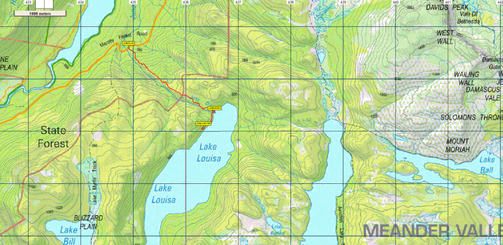
Lake Louisa sits between Lake Adelaide and Lake Bill in the Walls of Jerusalem National Park. Although there is an established track leading to it, this is not well-known and the lake is not often visited. Boots ‘n’ All has never been there either so this will be a rare opportunity to do so. The walk begins opposite a small car park on the Mersey Forest Road just before it crosses Juno Creek. (This is only about 300m before reaching the car park for the much better-known Lake Bill track often used to access such places as Lake Myrtle and Mt Rogoona.) The Lake Louisa track (aka Juno Creek track) heads uphill in a southeasterly direction through open and rocky forest, climbing, steeply at times, about 300m over the next 2 km. Then it flattens a little for the last 750m or so through some lovely rain forest before reaching Lake Louisa after about 2 hours walking. We will have a break there and explore the surrounding lake shore. We will hopefully then cross Juno Creek and head off track southwest for about 500m parallel to the lake shore to a fascinating small canyon. We will spend some time exploring this and then head back to cross Juno Creek again, pick up the track and return along it to the cars. We will have lunch either at the lake or at the canyon depending on weather and how the timing works out.
The walk will be about about 7 km return although if our exploration becomes more adventurous that may add a little distance. The walk follows a marked track to the lake, however the walk to the canyon is off track and could be uneven underfoot, requiring stepping or climbing over logs and rocks to reach it, and could be slippery in places. We will need to cross Juno Creek to get to the canyon and again on the way back and this could be slippery especially if there has been heavy rain in the days beforehand. If the creek is very full it may even mean that we cannot cross it safely. If so we will just return to the carpark along the track and will forego visiting the canyon. The walk is rated medium, and will be suitable for reasonably fit adults and energetic children.

Meeting Times and Places
If you are interested in going on this walk, please phone the walk leader, Phil Andrew, on 0408 014 757 or email pandrew.tas@gmail.com, to register. The departure time is 8:00 am from Door of Hope car park. Alternative meeting places en route are possible, such as the public toilets at Mole Creek at 8.50 am, however please arrange this with the leader. The leader should be notified of any other people you intend to bring along. Please be at any meeting place 5 minutes ahead of departure time.
To access this area from northern Tasmania:
Proceed along the Bass Highway to Deloraine (about 51 km), but do not turn off at the eastern exit into Deloraine. Instead, continue across Meander R. and up hill to the western exit, and to the roundabout at start of Mole Creek Rd. A further 24km will bring you to Mole Creek (sometimes used as a meeting place for our walks – check with leader). Continue west past Mole Creek, on what is now Liena Rd, making sure you turn south at the caravan park 4 km from the town. The road continues west until about 14 km from Mole Creek, it branches south, now called Mersey Forest Road. A little over 6 km south, you will pass turnoffs to Cradle Mountain and Devil’s Gullet (Lake Mackenzie) but keep going south, crossing the Mersey at Lake Parangana and passing the turnoffs for Bare Hill and Arm River. Another 17 km should see you cross below the Rowallan Dam. Continue south along the east side of Lake Rowallan, for just under 12km to reach the Juno Creek bridge. See notes above about the start of the track. Allow 1 hr 30 min for the drive from Launceston – about 130km.
Warnings:
The following codes apply from our 2025 walks calendar:
D Drive distance requires early departure
E Exposed alpine conditions – can be dangerous in poor weather if not fully equipped
S Steep incline for at least part of the way
Bushwalking can be dangerous in poor weather if not adequately equipped; For equipment guidelines, Click here.
Map details:
Lake Louisa: 1:100000 map is Mersey (Tasmap 8114) and 1:25000 map is Cathedral (4236)
Map reference: n/a
Zone Easting Northing Latitude Longitude
n/a
No peakbagger points or Abels will be reached on this walk. For explanation of this challenge, see Peakbaggers List 2017, which can be downloaded (Excel) from Peak Baggers and The Abel Mountains | Hobart Walking Club. At the time of writing, the website to which we used to link has been taken down, along with the 1983 and 2000 versions, developed from the original 1968 Hobart Walking Club version. We can’t guarantee that peaks you have bagged in the past are still on the current version. You can download the 2000 version from our website here [link]. A parallel and more recent but not identical list system is The Abels – also linked from the HWC website, which also contains some other listings of Tasmanian peaks.
For GPX (.gpx) and Google Earth (.kml) versions of the track: Click here to browse our collection.
Direct links: GPX for this walk ¦ KML for this walk
Right-click on the file and save target as to a location of your choice. (Suggest you click the Last modified at top to sort by date to get the most recent at top to find the file for the next walk).

