Overland Track (camping) 8-13 June 2025
For many decades, the Overland Track has been Tasmania’s most iconic wilderness walk. People come from all over the world to experience the remarkable beauty of what used to be called “The Reserve”, now part of the Tasmanian World Heritage Area. Very much an arduous wilderness experience in the early decades after it was pioneered in the early 1930s, it is now well-formed so the walking is vastly easier, although the ascents and descents are just as steep. For a glimpse of what it was like in the early days, see our 1937 – A Walk through the Overland Track video, based on a photo album assembled by the late Tas Calver and used by permission of his family.
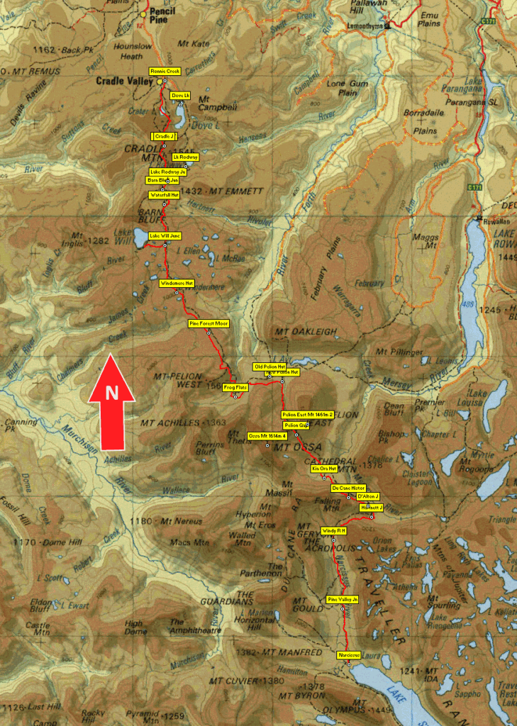
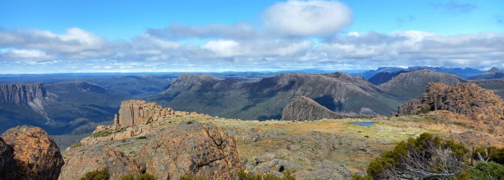
The Overland Track is a 65-kilometre multi-day hike, known for its challenging terrain, diverse landscapes, and stunning views. The track typically takes 6 days to complete. After the boat trip along Lake St Clair past Mts Olympus and Ida, it passes east of the DuCane Range, with impressive peaks such as The Acropolis, the twin-headed Mt Geryon and Falling Mountain, before rising between Mt Ossa and Mt Pelion East. Further north, it passes between Mts Pelion West and Oakleigh before reaching the final peaks which include Barn Bluff and Cradle Mountain. And of course, there are also the iconic lakes and waterfalls.
See also Overland Track walk notes | Parks & Wildlife Service Tasmania but note that Hannah’s walk will be south to north, and will not include what is listed as “Day 7” on that description.
Day 1: 8th June – Launceston – Windy Ridge Hut (Bert Nichols)
The first day we will drive the 2.5 hours from Launceston to Lake St Clair. See below for details of the essential ferry booking.
After reaching Narcissus Bay at the northern end of the lake, we will walk the 9km, 3-4 hours from Narcissus to Windy Ridge Hut.
Day 2: 9th June: Windy Ridge (Bert Nichols) – Kia Ora Hut
This section is 9.6km, 3.5-4.5 hours long. There are some short side trips to waterfalls, which could be quite impressive in winter.
Day 3: 10th June: Kia Ora – New Pelion Hut
Today will be 8.6km, 3-4 hours with a steeper elevation gain to reach Pelion Gap. Mount Ossa and Mount Pelion East side trips are from here, although their attempt will be weather dependent, as this area can become icy and slippery.
Day 4: 11th June: Pelion – Windermere Hut
Today is a bit of a longer day with 16.8km, 5-7 hours before the next hut. We’ll be traversing beautiful landscapes with rainforests and button grass plains.
Day 5: 12th June: Windermere – Waterfall Valley Hut
It’ll just be a short stretch to the next hut in 7.8km, 2.5-3.5 hours. There is a side trip to Lake Will along the way and winter should be a great time to experience why this place is called Waterfall Valley.
Day 6: 13th June: Waterfall Valley – Cradle Visitor Centre
This walk would rate as medium-hard due to the distances and the need to carry a heavy pack for the longer exit. Please discuss your level of experience with Hannah.
What to take:
You must be fully self-sufficient for this walk, including tent, sleeping gear, rain gear, stove and food. A checklist of essentials is a good idea. Parks and Wildlife Tasmania have a comprehensive Safety in Parks page which covers many aspects of bushwalking safety and equipment, including a Walker Pack List that is well worth a read. However, much of this gear can be shared with a partner – perhaps a more experienced walker who already has some of the big-ticket items such as tent and stove. This area is known to have four seasons in one day, including blizzards in summer, so walkers must be prepared for anything, despite what the forecast may say.
While the intention is to stay in the huts, a tent is needed in case huts are full. In that case, the camping platforms will be used.
Note also that a valid Parks Pass is needed for each vehicle, or you may have registered as an individual.
Booking Details, Meeting Times and Places:
If you are interested in going on this walk, please phone Hannah Waterhouse on 0427 026 233 to book in, by Sunday night, 25th May, so that car/bus, ferry, tent sharing etc can be arranged. Note that this walk is limited to 10 people, so contact Hannah early to make sure of your place! Also…
Online Registration required! Current SU safety regulations require completion of an online registration form for all overnight camping trips. You must still contact Hannah, however, to confirm that this is the right walk for you. Click here [link] to register online.
Getting there:
If you would like to come on this walk, please note that you must book your own ferry trip. The cost is $55 per adult. Please contact Lake St Clair Lodge and book the 12:30 ferry departing from Cynthia Bay to Narcissus on 8th June. If this is full, then book the 15:00 ferry and we will make it work. As it’s a long weekend, it’s advised to make this booking as soon as possible.
Details of the ferry service can be read at https://www.lakestclairlodge.com.au/lake-st-clair-ferry-service
Contact details to book: sceniccruises@lakestclairlodge.com.au or Ph. 03 6289 1137
Your leader is in the process of organising a small bus to drive us to and from the walk. There will be a hire cost, which is yet to be confirmed, but is expected to be approximately $50-75pp each way. Please note that this considerably cheaper than transport companies. However, if you would like to organize your own transport, let Hannah know as soon as possible.
The departure time is 8 am from Door of Hope carpark in South Launceston. Additional meeting points can be arranged if needed. However, you still need to contact the walk leader per details above if intending to walk. The leader should be notified of any other people you intend to bring along. Please be at any meeting place 10 minutes ahead of departure time.
To access this area from northern Tasmania:
From Launceston, head towards Deloraine on the Bass Highway (50 km) and take the first (eastern) turn from the highway into Deloraine. Continue into the town and turn left immediately before the bridge (unless the group is using the train park across the bridge as a meeting place – see above). From Deloraine, head south along the “Lake Highway” – now Highland Lakes Rd. (but the first bit may be called Meander Rd!). Make sure to turn left after 7 km at signposted junction for Highland Lakes Rd. Continue south through Golden Valley, up past Quamby Bluff and Projection Bluff, and south along the western side of Great Lake. 52 km from the junction and 59 km from Deloraine, you pass through Liawenee, and continue another 9 km south to junction of Marlborough Rd. Turn right and follow through this gravel road, past Bronte Park to the Lyell Highway (about 30 km). Turn right, and head another 25 km west to reach Derwent Bridge. The road to Lake St Clair is on the right, just past the bridge. Follow the road for 5 km to reach Cynthia Bay, with its car parks and visitor centre, where the boat trip begins.
Warnings:
The following codes [from our 2025 walks calendar] apply:
E Exposed alpine conditions – can be dangerous in poor weather if not fully equipped – see below.
S Steep incline for at least part of the way
L A long day’s walk – distances each day aren’t huge, but with a heavy pack, they will seem longer.
Much of this walk is at altitude 1000m or higher, with sections at 1100 and 1200m altitude, and can be very exposed if the weather is bad. Be prepared! Walkers should wear very sturdy and supportive footwear due to uneven surfaces. Gaiters can add support and comfort, even when walking on-track. You will most definitely need carry wet weather gear as well as warm clothing in case of sudden weather changes. For equipment guidelines, CLICK HERE.
Map details:
Overland Track: 1:100000 maps are Sophia (8014) and Mersey (8114) and 1:25000 maps are Olympus (4234), DuCane (4235), Cathedral (4236), Will (4037) and Cradle (4038).
If the group should happen to find the energy and time, and if weather and conditions permit, Mt. Ossa is worth 4 peakbagger points and Mt. Pelion East is worth 2 points. There are unlikely to be other peakbagging options on the walk. For explanation of this challenge, see Peakbaggers List 2017, which can be downloaded (Excel) from Peak Baggers and The Abel Mountains | Hobart Walking Club. At the time of writing, the website to which we used to link has been taken down, along with the 1983 and 2000 versions, developed from the original 1968 Hobart Walking Club version. We can’t guarantee that peaks you have bagged in the past are still on the current version. You can download the 2000 version from our website here [link]. A parallel and more recent but not identical list system is The Abels – also linked from the HWC website, which also contains some other listings of Tasmanian peaks.
For GPX (.gpx) and Google Earth (.kml) versions of the track: Click here to browse our collection.
Direct links: GPX for this walk ¦ KML for this walk
Right-click on the file and save target as to a location of your choice. (Suggest you click the Last modified at top to sort by date to get the most recent at top to find the file for the next walk).