Holwell Gorge and Notley Fern Gorge Sat. 9th August 2025
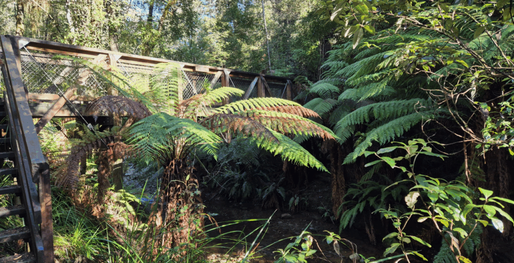
Holwell Gorge, until 2016, was a delightful and fairly short “through” walk along a well-formed track. The track was badly damaged during storm and flood events in 2016, and has not yet been fully restored, so our aim is to walk in to falls close to the top end of the track, and then drive further to walk upstream to the main falls closer to the bottom end of the track. About 1 km is missed in the middle, more than made up for by the need to walk back to the carparks at each end!
And to make the day a little bit longer and more interesting, we will start by walking the Notley Fern Gorge circuit on the way from Launceston. See Notley Fern Gorge | Nature and wildlife | Discover Tasmania for a description of this walk – not particularly challenging, but descending fairly steeply to the bottom of the gorge, with a steep ascent to get back to the carpark.
It will not be a particularly long day, with a total of just under 5 km walking. Moderately fit adults and energetic children should easily cope with the conditions. We will likely have a lunch break at the lower falls.
Meeting Times and Places:
If you are interested in going on this walk, please phone or text your walk leader, ph. 0438 664 402 to book in. The departure time is 9:00 am from the Door of Hope Church car park, Launceston.
If you would like to arrange to meet the group elsewhere, please arrange with the leader, and please be at any meeting place 5 minutes ahead of the listed time. The leader should always be notified of any other people you intend to bring along, and you should always contact the walk leader if intending to participate in a particular Boots N’ All walk.
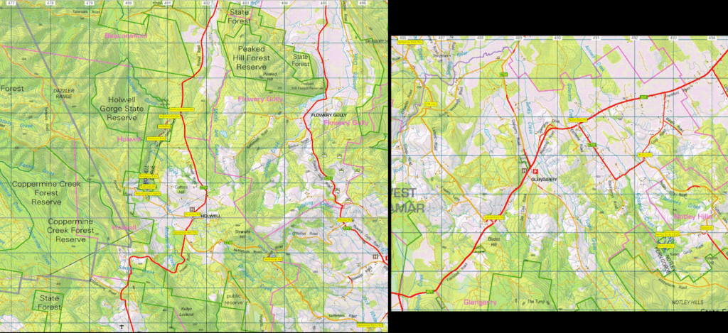
To access this area from northern Tasmania: This route takes us from Launceston to Notley Fern Gorge, and then on to Holwell Gorge. If coming from other parts of the state, please meet us at the Notley Fern Gorge carpark, about 9:50 am.
From Launceston, follow the West Tamar Highway through Riverside and continue to the United service station just short of Legana. Turn left into Bridgenorth Rd C732. Continue west for 8.4km past Long Plains Rd and turn right into Notley Rd C731. Head north for 3.8 km and continue right for just under 1km to reach Notley Fern Gorge carpark.
If coming from the northwest or via Exeter, the Frankford Rd (Hwy) B71 can be used to reach the northern end of Notley Rd C731. From that end, it is just under 7 km with several sharp bends, to reach the Gorge carpark. It will hopefully be well signposted.
After the Notley Fern Gorge walk, we follow the same road just under 1 km but then turn north to continue along Notley Gorge Rd C731 for 6 km through some sharp bends to reach Frankford Rd (Hwy) B71. Turn right and continue west, then SW for 3.6km to reach Lamont Rd C716 and turn right. Head north for 5.8 km and continue on Nettlefolds Rd, still C716 for a further 6.2km to reach Holwell Rd C715. Turn right and head north for 600m and turn left into Kerrison’s Rd. The top car park for the gorge is about 1.5km along.
After we have walked the top part of the gorge, we will return to the cars and back to Holwell Rd, turn left and continue just over 3 km to reach the short, somewhat rough track to the Holwell Gorge car park and picnic area.
Warnings:
Please take note of the weather forecast on the day. Be aware of possible hazards such as slippery paths and rocks, and insect bites.
Wear sturdy shoes. Gaiters are not necessary for today’s walks. You should always carry a drink, a snack, warm clothes and a raincoat. It is still winter!
Map details and references:
For Holwell Gorge, 1:100000 map is Tamar (Tasmap 8215) and 1:25000 map is Beaconsfield (TasMap 4843).
For Notley Fern Gorge, same Tamar map but Exeter (Tasmap 4842).
Holwell Gorge: Short ref. n/a
Zone Easting Northing Latitude Longitude
55G -41.16.543 146.46.022
Three are no peakbagger points associated with this walk. For explanation of this challenge, see Peakbaggers List 2017, which can be downloaded (Excel) from Peak Baggers and The Abel Mountains | Hobart Walking Club. At the time of writing, the website to which we used to link has been taken down, along with the 1983 and 2000 versions, developed from the original 1968 Hobart Walking Club version. We can’t guarantee that peaks you have bagged in the past are still on the current version. You can download the 2000 version from our website here [link]. A parallel and more recent but not identical list system is The Abels – also linked from the HWC website, which also contains some other listings of Tasmanian peaks.
For GPX (.gpx) and Google Earth (.kml) versions of the track: Click here to browse our collection.
Direct links: GPX for this walk ¦ KML for this walk
Right-click on the file and save target as to a location of your choice. (Suggest you click the Last modified at top to sort by date to get the most recent at top to find the file for the next walk).