Upper Liffey River – Sat. 6th September 2025
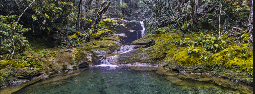
Our first walk of spring takes us to the upper Liffey River and Liffey Falls area. It’s an area that begins in a heavily forested area with a remnant giant tree, and as it ascends, begins to transform to higher alpine woodland along a picturesque river with several photogenic cascades.
Walk Route:
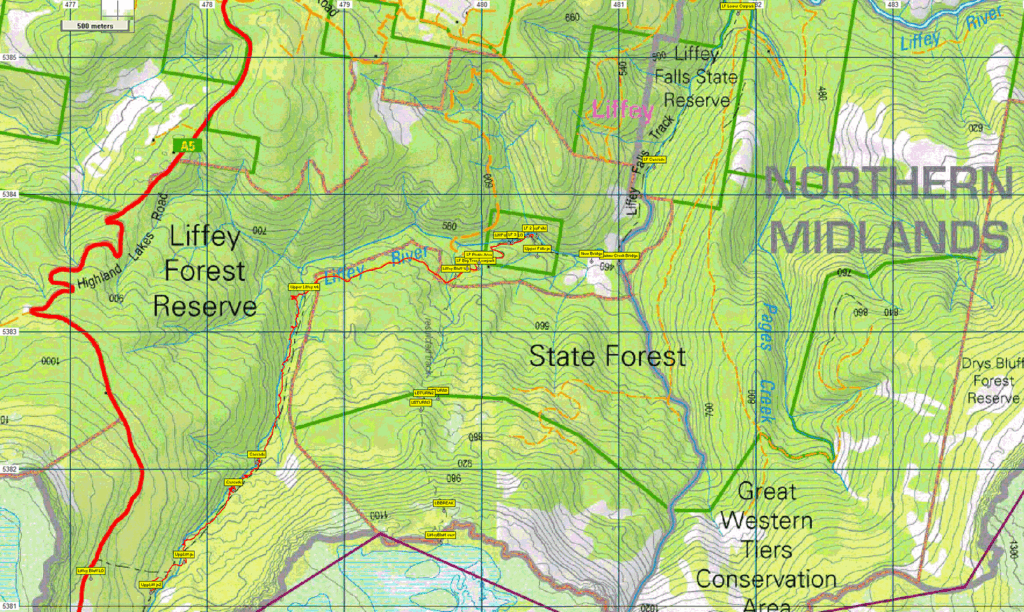
Starting from the Upper Liffey Falls carpark, your leader will take you downhill for a few hundred metres to the main Liffey Falls, likely viewed from the top. A couple of other very nice cascades will be seen on the way back to the carpark. The walk then passes the giant tree, heading west for a little more than a km, then following south up the Liffey River, hopefully for 1 km or more, depending on track conditions and the speed of the group. The distance covered may also depend on the level of water flowing in the river, and dangerous crossings will not be attempted. The group will return to the carpark by the same route.
This walk is rated easy-medium, with marked, fairly well-formed tracks, and while there are steep inclines and slippery places, there will not be any boulder fields to cross. The walk would suit energetic children. Much of the walk will be through forest, with some examples of very large eucalypts. Some background information about the area can be found on Liffey Falls State Reserve | Parks & Wildlife Service Tasmania
Meeting Times and Places:
If you are interested in going on this walk, please phone or text your walk leader, Grace Hillman on 0490 840 866 to book in.
The departure time is 8:30 am from the Door of Hope Church car park, Launceston.
If you would like to arrange to meet the group at Deloraine or elsewhere, please arrange with the leader, and please be at any meeting place 5 minutes ahead of departure time.
The leader should always be notified of any other people you intend to bring along, and you should always contact the walk leader if intending to participate in a Boots N’ All walk.
To access this area from northern Tasmania: There are alternative ways to access the walk from Launceston:
a) via Deloraine: Head towards Deloraine on the Bass Highway (50 km) and take the first (eastern) turn from the highway into Deloraine. Continue into the town and turn left immediately before the bridge (or go to arranged meeting place -often, but not always, at the “train park” across bridge). From Deloraine, head south along the “Lake Highway” – now Highland Lakes Rd. (but the first bit may be called Meander Rd!). Make sure to turn left after 7 km at signposted junction for Highland Lakes Rd. Continue south through Golden Valley until you reach the Riversdale Rd. junction, about about 7 km from the signposted junction for Highland Lakes Rd. Turn left into Riversdale Road and follow the signs. The road into the upper carpark (a further 5 km) is unsealed and narrow, with sharp bends. Please exercise care on this road. A map of the local roads can be found at Liffey Falls State Reserve | Parks & Wildlife Service Tasmania (the map zooms in when you scroll). Further variants of this route can be followed through Quamby Brook.
b) via Bracknell: Head towards Devonport on the Bass Highway ( Hwy. 1) but at 22 km from Launceston, turn left into Oaks Road (C511) at the Liffey Falls exit. Drive past the Agfest site, and continue to Bracknell (12 km). Turn right into Bracknell Rd (C513) and follow 7 km to junction of Liffey Rd (C513). After about 4 km at a bridge, this becomes Gulf Rd, still C513. It will take you to the lower Liffey Falls car park, but continue! The road, still C513, now becomes Bogan Rd. Keep going 5.5km past the lower Liffey Falls carpark to reach Riversdale Rd. Turn left, and continue 3.6km to reach the Upper Liffey Falls carpark.
Bracknell can also be accessed by other roads from further east if you are familiar with the area.
The roads in the area are gravel, steep in places, and fairly narrow with some tight bends. Drive carefully! It may be best to drive in a convoy with your leader if unsure about the way. Signposting should be helpful.
Warnings:
While less exposed than the open plateau above, the area is about 600m above sea level, and subject to showers, snow falls and icy winds. Walkers should be equipped for cold and possibly wet conditions, and wear warm clothing. Gaiters can increase comfort levels and make it harder for leeches to reach your skin.
You should always carry wet weather gear as well as warm clothing in case of sudden weather changes.
Follow this link for further information on clothing suggestions for exposed conditions.
Click this link for a more detailed discussion of Preparation, Food and Safety guidelines for Boots N’ All walks.
Map details:
Liffey Falls: 1:100000 map is Meander and 1:25000 map for upper area is Quamby Bluff (TasMap 4638), and Liffey (TasMap 4838) for the falls and below.
Map reference:
n/a
Zone Easting Northing Latitude Longitude
n/a
While there are no peakbagger points for the section covered by the intended walk, Liffey Bluff, is directly above the walk area, and is worth 1 peakbagger point. For explanation of this challenge, see Peakbaggers List 2017, which can be downloaded (Excel) from Peak Baggers and The Abel Mountains | Hobart Walking Club. At the time of writing, the website to which we used to link has been taken down, along with the 1983 and 2000 versions, developed from the original 1968 Hobart Walking Club version. We can’t guarantee that peaks you have bagged in the past are still on the current version. You can download the 2000 version from our website here [link]. A parallel and more recent but not identical list system is The Abels – also linked from the HWC website, which also contains some other listings of Tasmanian peaks.
For GPX (.gpx) and Google Earth (.kml) versions of the track: Click here to browse our collection.
Direct links: GPX for this walk | KML for this walk
Right-click on the file and save target as to a location of your choice. (Suggest you click the Last modified at top to sort by date to get the most recent at top to find the file for the next walk).