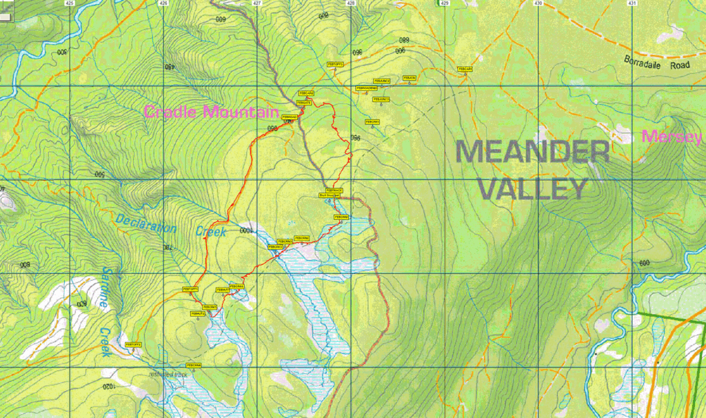
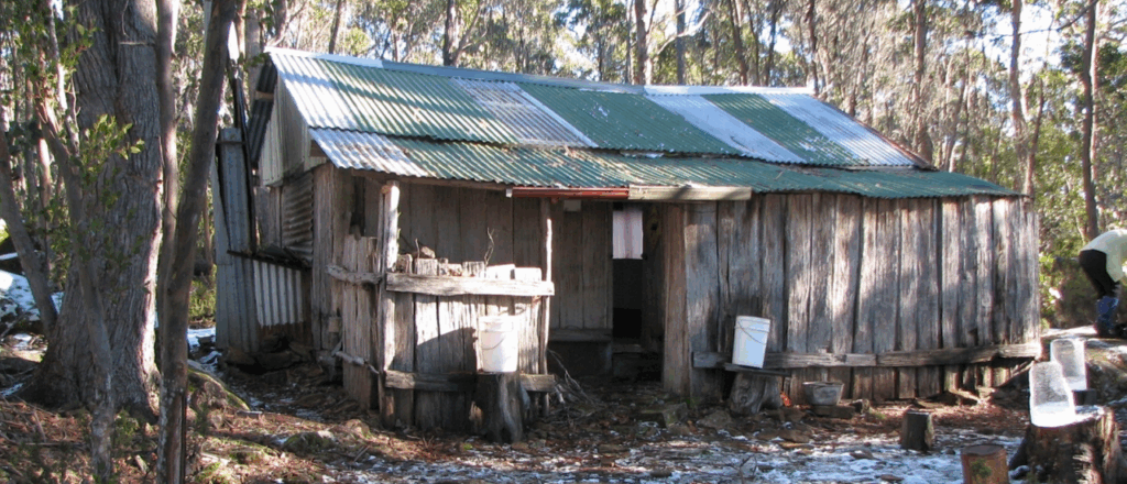
Basil Steers Huts Circuit – Sat. 20th September 2025
This walk takes us to the reconstructed Steer’s No. 1 & 2 Huts on the February Plains in the high country west of Lake Rowallan. After about 1.5-2 hours drive (ex Launceston) up to the Borradaile Plains with the last few km on generally good dirt roads, we will park and begin the reasonably easy walk to the hut at the northern end of the February Plains. This is along a well-marked track through the forest, climbing about 100 metres during the first hour. After a look around, we will head to the next hut for lunch, exploring the open February Plains on the way.
Our return journey takes us down onto an old logging track and road, eventually returning to the starting point.
Total walk distance is about 8 km, with long sections of relatively level walking over the high plain and along the old roads.
The walk is rated easy-medium and would be suitable for children. However, the track will probably be waterlogged in a couple of places. Good boots will be helpful to you can keep your feet dry. As it is an alpine area with changeable weather, normal precautions should be taken against cold and rain.
Meeting Times and Places:
If you would like to participate please telephone the walk leader, Ian Waterhouse, on 0428 242 693. We will meet at the Door of Hope car park in Launceston at 8 am. Meeting points along the way could be 8.30 at the Mole Creek Road roundabout at the western end of Deloraine, 8.50 at Mole Creek toilet block. Our return time will depend on weather, how the group fares and how much time is spent up top, but should be between 4-6 pm in Launceston.
If you would like to arrange to meet the group at these places or elsewhere, please arrange with the leader, and please be at any meeting place 5 minutes ahead of the listed time. It is also courtesy to let the leader know if you have changed plans and are no longer coming.
The leader should always be notified of any other people you intend to bring along, and you should always contact the walk leader if intending to participate in a particular Boots N’ All walk.
To access this area from northern Tasmania: From Launceston, proceed along the Bass Highway to Deloraine (about 51 km), but do not turn off at the eastern exit into Deloraine. Instead, continue across Meander R. and uphill to the western exit, and to the roundabout at start of Mole Creek Rd. A further 24km will bring you to Mole Creek (toilet block is on the left about halfway through the town). Continue west past Mole Creek, on what is now Liena Rd (still B12), making sure you turn south at the caravan park 4 km from the town. The road continues west until about 14 km from Mole Creek, it branches south as Mersey Forest Road (C138). A little over 6 km south, you will pass turnoffs to Cradle Mountain and Devil’s Gullet (Lake Mackenzie) but keep going south, now C171). crossing the Mersey at Lake Parangana. The Bare Hill Rd. turnoff is about 6.5km south of the bridge. Turn right and follow up the winding road. About 5km will bring you to the Borradaile Rd. turnoff. Turn left. Another 3.5 km will take you to the turnoff for February Plains.
Warnings:
A reminder that weather in Tasmania can be very changeable in early spring, so warm clothing, suitable footwear and a raincoat should be carried.
The following codes [from our 2025 walks calendar] apply:
D Drive distance requires early departure
M Marshy or muddy sections – be prepared to walk with wet feet.
Click this link – Preparation, Food and Safety – for a more detailed discussion of guidelines for Boots N’ All walks, and especially preparation for exposed alpine conditions.
Map details:
February Plains: 1:100000 map is Mersey (Tasmap 8114) and 1:25000 map is Borradaile (TasMap 4238)
Map reference:
n/a
Zone Easting Northing Latitude Longitude
n/a
There are no peakbagger points for the area covered by this walk. For explanation of this challenge, see Peakbaggers List 2017, which can be downloaded (Excel) from Peak Baggers and The Abel Mountains | Hobart Walking Club. At the time of writing, the website to which we used to link has been taken down, along with the 1983 and 2000 versions, developed from the original 1968 Hobart Walking Club version. We can’t guarantee that peaks you have bagged in the past are still on the current version. You can download the 2000 version from our website here [link]. A parallel and more recent but not identical list system is The Abels – also linked from the HWC website, which also contains some other listings of Tasmanian peaks.
For GPX (.gpx) and Google Earth (.kml) versions of the track: Click here to browse our collection.
Direct links: GPX for this walk | KML for this walk
Right-click on the file and save target as to a location of your choice. (Suggest you click the Last modified at top to sort by date to get the most recent at top to find the file for the next walk).