Moses Creek Waterfalls – Sat. 22nd November 2025
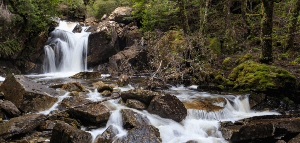
Late spring is a great time to explore waterfalls in the vicinity of Chapter Lake and Moses Creek. There will hopefully still be plenty of water flowing (but also hopefully a dry day!) According to one of our most seasoned walkers and leaders, this walk represents by far the best waterfall circuit walk in the state!
Walk Description
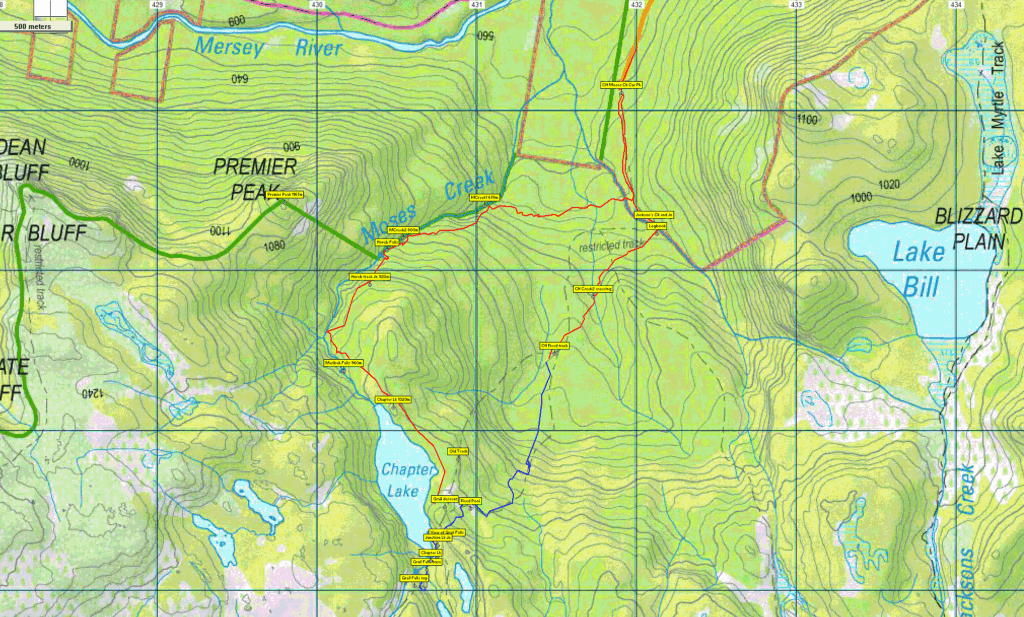
The walk begins at the very end of the Mersey Forest Road, south of Lake Rowallan. A kilometre south, after crossing the Jackson Creek footbridge, the route heads west for a few hundred metres to reach Moses Creek, which is then followed uphill, rising nearly 200m, for just under a kilometre to reach Horeb Falls. The best part of another km upstream, with a further 150m climb, brings the walkers to Meribah Falls, which is less than 200 metres from the north end of Chalice Lake. The going is somewhat scrubby from Meribah Falls to the Grail Falls track, a little over a kilometre away via the eastern shore of the lake. From Grail Falls, the Junction Lake track is followed back to the Jackson Creek crossing and the car. Total walk distance is about 10km. Because of the off-track walking and patches of scrub, this walk should be considered medium-hard, but energetic and resilient older children would manage it well.
Meeting Times and Places:
If you are interested in going on this walk, please phone Phil Dawson on 0417 527 511 or email pidasms@gmail.com to book in by Thurs. evening. The departure time is 7:30 am from Door of Hope southern car park. If you wish to meet with the group at any other place, please arrange with the leader. Please be at any meeting place 5 minutes ahead of departure time. However, you still need to contact the walk leader per details above if intending to walk. The leader should be notified of any other people you intend to bring along.
To access the area from Launceston, proceed along the Bass Highway to Deloraine (about 51 km), but do not turn off at the eastern exit into Deloraine. Instead, continue across Meander R. and up hill to the western exit, and to the roundabout at start of Mole Creek Rd. A further 24km will bring you to Mole Creek (sometimes used as a meeting place for our walks – check with leader). Continue west past Mole Creek, on what is now Liena Rd, making sure you turn south at the caravan park 4 km from the town. The road continues west until about 14 km from Mole Creek, it branches south, now called Mersey Forest Road. A little over 6 km south, you will pass turnoffs to Cradle Mountain and Devil’s Gullet (Lake Mackenzie) but keep going south, crossing the Mersey at Lake Parangana and passing the turnoffs for Bare Hill and Arm River. Another 17 km should see you cross below the Rowallan Dam. Continue south along the east side of Lake Rowallan, for about 16 km, by which time you are south of Lake Rowallan, until you reach the very end of the road and the beginning of the Moses Creek walking track.
Warnings:
The following codes [from our 2025 walks calendar] apply:
D Drive distance requires early departure
S Steep incline for at least part of the way
L A long days walk in excess of 3 hours each way
M Marshy or muddy sections be prepared to walk with wet feet.
E Exposed alpine conditions ; can be dangerous in poor weather if not adequately equipped; see Preparation, Food and Safety for some guidelines.
No peakbagger points will be reached on this walk. For explanation of this challenge, see Peakbaggers List 2017, which can be downloaded (Excel) from Peak Baggers and The Abel Mountains | Hobart Walking Club. At the time of writing, the website to which we used to link has been taken down, along with the 1983 and 2000 versions, developed from the original 1968 Hobart Walking Club version. We can’t guarantee that peaks you have bagged in the past are still on the current version. You can download the 2000 version from our website here [link]. A parallel and more recent but not identical list system is The Abels – also linked from the HWC website, which also contains some other listings of Tasmanian peaks.
For GPX (.gpx) and Google Earth (.kml) versions of the track: Click here to browse our collection.
Direct links: GPX for this walk | KML for this walk
Right-click on the file and save target as to a location of your choice. (Suggest you click the Last modified at top to sort by date to get the most recent at top to find the file for the next walk).