Mt Maurice – Sat. 6th December 2025
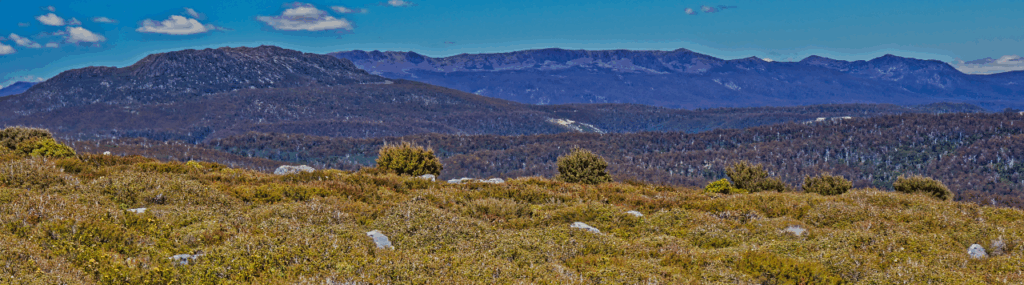
Mt. Maurice is an open-topped mountain north-east of Mt. Barrow and offers views of the northeast forests and out to the north coast. Waratah and wildflowers are usually in season by early December!
Walk route:
The eastern Mt. Maurice track is approx. 3.5 km each way, rising about 250 metres through forest and alpine vegetation to an open, relatively flat summit plateau. It is some years since the roads to both the eastern and western tracks to Mt. Maurice have been maintained, and this means an extra 30 minutes of road walking, bringing the total for the day to about 11km. The track is still quite walkable, and not particularly challenging. Rated medium, energetic and resilient children should find it quite manageable.
Meeting Times and Places:
If you are interested in going on this walk, please contact Peter Davies on 0414 516 268 to book in. Peter will be out of state until 5th December, so to book in earlier, please leave details with Basil Tkaczuk on 0438 664 402. Peter promises to be back for the walk, though!
The departure time is 8:00am from Door of Hope southern carpark. The alternative meeting place is at the entrance to Myrtle Park at 8:30 am. If you wish to meet with the group at any other place, please arrange with the leader. Please be at any meeting place 5 minutes ahead of departure time. However, you still need to contact the walk leader per details above if intending to walk. The leader should be notified of any other people you intend to bring along.
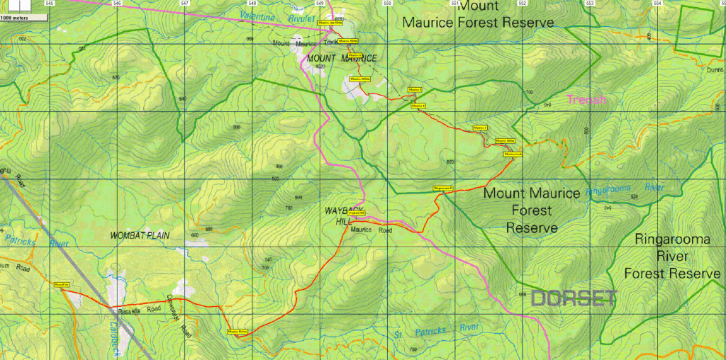
To access this area from northern Tasmania: From Launceston, proceed along the Tasman Hwy (A3) through Waverley and continue 33 km to reach the Myrtle Park picnic ground gate. After joining with any vehicles meeting us there, continue a further 500 metres and turn right into Camden Hill Rd. (C405) After approx. 6.5 km, turn left into Diddleum Rd, and after a further 2.5 km, take the right turn at the junction of East Diddleum Rd. A further 7.5 km along Diddleum Rd will bring you to the junction of Russell’s Rd. Turn left, and after 3 km, turn left again into Maurice Rd. A further 5.5 km should bring you to the start of the Mt. Maurice track. Per above, note that the final part of the roads described is not accessible by vehicle.
Warnings:
S Steep incline for at least part of the way
Make sure you have a good supply of drinking water.
There may be fallen trees to clamber over, and walkers are advised to wear strong shoes or boots. You should always carry wet weather gear, even in early summer. See Preparation, Food and Safety for some guidelines on equipment for bushwalking.
Map details:
Mt. Maurice: 1:100000 map is Forester and 1:25000 map is Maurice
Map reference:
Short ref. is 491270
Zone Easting Northing Latitude Longitude
55G 5 49 145 54 27 200 -41.30516 147.58707
Mt Maurice is worth 1 peakbagger point. For explanation of this challenge, see Peakbaggers List 2017, which can be downloaded (Excel) from Peak Baggers and The Abel Mountains | Hobart Walking Club. At the time of writing, the website to which we used to link has been taken down, along with the 1983 and 2000 versions, developed from the original 1968 Hobart Walking Club version. We can’t guarantee that peaks you have bagged in the past are still on the current version. You can download the 2000 version from our website here [link]. A parallel and more recent but not identical list system is The Abels – also linked from the HWC website, which also contains some other listings of Tasmanian peaks.
For GPX (.gpx) and Google Earth (.kml) versions of the track: Click here to browse our collection.
Direct links: GPX for this walk | KML for this walk
Right-click on the file and save target as to a location of your choice. (Suggest you click the Last modified at top to sort by date to get the most recent at top to find the file for the next walk).