
Cradle Fagus Appreciation Walk – Sat. 10th May 2025
With our Magnet and Cleveland Mines walk cancelled due to leader knee problem, Grace has kindly stepped in to offer a further fagus walk, in the hope that there will still be plenty of colour, two weeks after our Grail Falls walk. At that time, much of the fagus was still semi-green, so hopefully there will be lots to see, and the weather forecast, at time of writing, is acceptable.
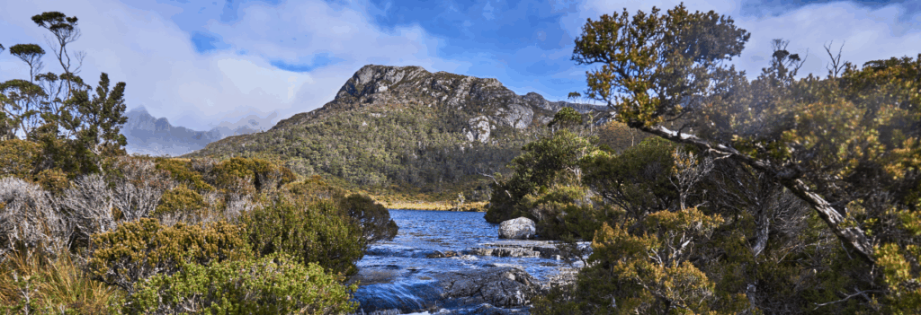
A highlight of the bushwalking year in Tasmania is to enjoy the blazing colour of the “fagus” in the high alpine areas. It has been an annual Boots N’ All tradition for over a decade to have a “Fagus Appreciation Walk” in late April or early May, mostly at Cradle Mountain, but in some years at Grail Falls in the upper Mersey area – not accessible this year due to a washed out bridge, so back to the spectacular surrounds of Cradle Mountain. As usual, we can’t guarantee the weather, or that our planned walk coincides with the peak of the fagus colour, but Cradle is always a special place to visit, so why not join us?
What is Fagus? hat is Fagus? See https://parks.tas.gov.au/discovery-and-learning/plants/fagus for a great description.
This walk is rated “medium” and is suitable for walkers, including children, who have had some experience with tracks of varying quality – part boardwalk, part steep and rocky path, which can be uneven and demanding in a few places, and able to keep going for sustained distances (see below – the shorter walk is more likely…) Because of the exposed alpine conditions, walkers must be fully prepared for poor weather. Please see the warnings and equipment suggestion link below.
Walk Route:
Private vehicle access to Ronny Creek and Dove Lake is very restricted, so we will catch the shuttle bus from the Visitor Centre. This costs $15 per person. The route on the day will begin from either Dove Lake or Ronny Creek. Note that you, or the vehicle you travel in, should hold a current Tasmanian Parks Pass.
The most likely route for the day will begin at Ronny Creek, heading up via the very pretty Horse Track Falls to Crater Lake, then sidle around to Wombat Peak before descending the Wombat Creek track to Lake Lilla and thence to Dove Lake to pick up the shuttle bus.
A much longer and more challenging route again starts from Ronny Creek, ascending via Crater Lake to Marion’s Lookout. This includes some very steep pinches, but slightly more altitude to gain, and about 1.7 km longer than the alternative route from Dove Lake (alt. 940m), which skirts around the western shore of the lake for about 1 km before rising very steeply to the west over the next km to reach Marions Lookout (1180m). The track continues south for the next 2 km over a relatively level and open alpine plateau to Kitchen Hut (alt. 1230m). From there, the Face Track branches off to the east, sidling and declining around the northern ridges of Cradle Mountain and Little Horn. After 1.5 km, the Lake Wilks track is followed down a steep descent to Lake Wilks, and then north to meet the Dove Lake Circuit Track which will be followed either north (shorter but a little harder) or east, then north, to reach the Dove Lake carpark.
Even the Dove Lake circuit can provide spectacular fagus views, especially if a side trip is taken from the southern end to Lake Wilks, which sits below extensive fagus slopes.
Meeting Times and Places:
If you are interested in going on this walk, please phone or text your walk leader, Grace Hillman, ph. 0490 840 866 to book in. to book in. The departure time is 7:00 am from the Door of Hope Church car park, Launceston. Suggested meeting places if coming from elsewhere could be Sheffield at Claude Rd. turnoff at 7:50 am or Moina at 8:20 am. The group should arrive at the Visitor Centre by approx. 8:35 am. If you would like to arrange to meet the group at these places or elsewhere, please arrange with the leader, and please be at any meeting place 5 minutes ahead of the listed time. The leader must be notified of any other people you intend to bring along.
To access this area from northern Tasmania: Roads to Cradle Mt. are well signposted, and the area can be accessed from several directions. From Sheffield, go south along Claude Rd through Gowrie Park and westward down into the Forth Valley (now Cethana Rd.), continuing up the other side to Moina. Turn south into Cradle Mt. Rd. After approx. 20 km, you will reach the Cradle Mt. turnoff. Turn left (still called Cradle Mt. Rd.) and 3 km south, the Visitor Centre and shuttle bus terminus are on the left.
Warnings:
The following codes [from our 2025 walks calendar] apply:
D Drive distance requires early departure
M Marshy or muddy sections – be prepared to walk with wet feet.
S Steep incline for at least part of the way
E Exposed alpine conditions – can be dangerous in poor weather if not adequately equipped.
Click this link for a more detailed discussion of Preparation, Food and Safety guidelines for Boots N’ All walks.
Map details:
Waldheim/Dove Lake/Cradle Mt area: 1:100000 map is Sophia and 1:25000 map is Cradle.
Map reference: 126845 (Cradle Mountain)
Zone Easting Northing Latitude Longitude
55G 4 12 730 53 84 690 -41.68478 145.95140
No peakbagger points will be visited on this trip, although there are several in the immediate area for your future challenges, including Mts Kate, Campbell, Emmett, Little Horn, Cradle Mt and Barn Bluff. For explanation of this challenge, see Peakbaggers List 2017, which can be downloaded (Excel) from Peak Baggers and The Abel Mountains | Hobart Walking Club. At the time of writing, the website to which we used to link has been taken down, along with the 1983 and 2000 versions, developed from the original 1968 Hobart Walking Club version. We can’t guarantee that peaks you have bagged in the past are still on the current version. You can download the 2000 version from our website here [link]. A parallel and more recent but not identical list system is The Abels – also linked from the HWC website, which also contains some other listings of Tasmanian peaks.
For GPX (.gpx) and Google Earth (.kml) versions of the track: Click here to browse our collection.
Direct links: GPX for this walk KML for this walk
Click here to learn about using your phone as a navigation device, or to find out about handheld GPS devices.
