Split Rock and Shower Cave Falls Sat. 12th July 2025
Here’s an opportunity for a short but steep walk in the Meander area to some very pretty falls high above the Meander River valley.
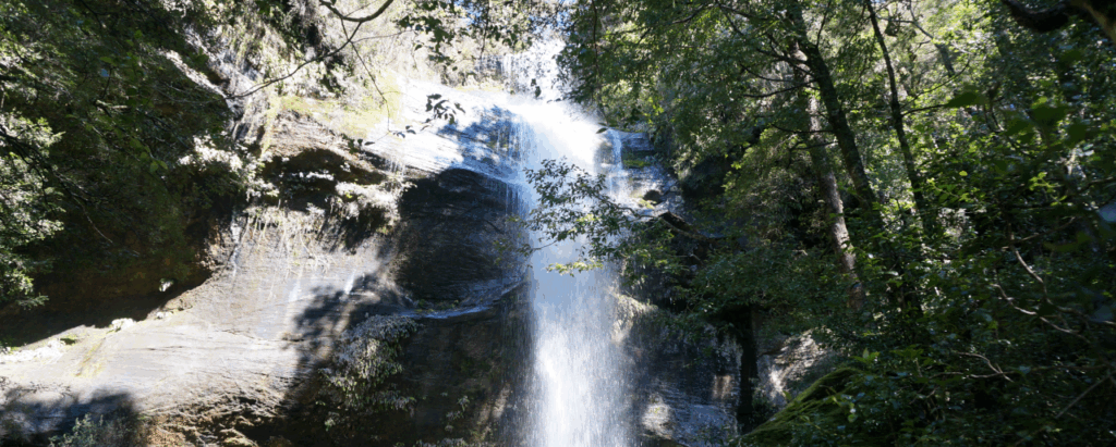
From the Meander Falls car park (altitude 600m), the track crosses the river by a suspension bridge, and then climbs steadily westwards up what is known as the Cleft Rock track, often referred to as Split Rock. After about 1 km of steady climbing, a diversion to the left follows the course of the creek on which both falls are found. Shower Cave Falls (alt. 830m) can be found about 200m on from the diversion, and Split Rock Falls (alt. 900m) less than 200m further on. Your leader is planning to head a little further up the hill so the group can descend through the interesting cleft that gives the area its name.
The walk is rated medium due to the steep and at times rough nature of the track, and the possibility of cold and wet conditions. It should be suitable for energetic and resilient children, but please consult with walk leader.
Meeting Times and Places:
If you are interested in going on this walk, please contact Phil Dawson email pidasms@gmail.com or ph. 6382 3561 after 6:30 pm. The departure time is 7:45 am from Door of Hope car park. Alternative meeting place: Deloraine 8:15 am. Check with leader for meeting spot. If you wish to meet with the group at any other place, please arrange with the leader. However, you still need to contact the walk leader, if intending to walk. The leader should be notified of any other people you intend to bring along. Please be at any meeting place 5 minutes ahead of departure time.
To access this area from northern Tasmania: From Launceston, head towards Deloraine on the Bass Highway (50 km) and take the first (eastern) turn from the highway into Deloraine. Continue into the town and turn left immediately before the bridge (meeting place – see above).
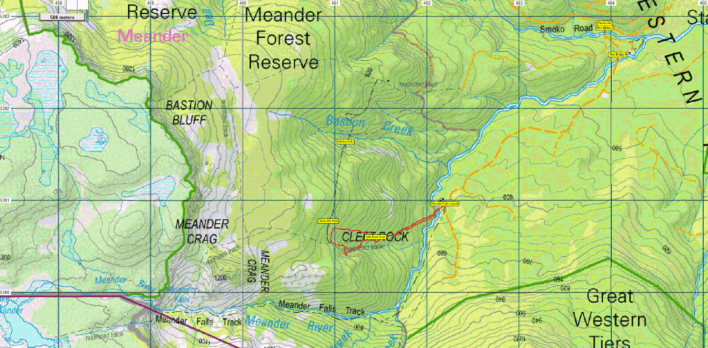
From Deloraine, head south along the “Lake Highway” – now Highland Lakes Rd. (but the first bit may be called Meander Rd!). Make sure you stay on Meander Rd and go straight ahead – DON’T turn left at 7 km from Deloraine, where there is a signposted junction for Highland Lakes Rd. Continue a further 9 km to Meander and continue through the town. After about 6 km, the road swings right. About 2.5 km further, the road turns south and crosses the first of the new bridges (Smoko Creek), followed shortly by the 2nd bridge which takes you across the Meander R. Less than 3 km further, you will reach the Meander Falls car park and the beginning of the walking track.
Warnings:
The following codes [from our 2025 walks calendar] apply:
S Steep incline for at least part of the way
M Marshy or muddy sections be prepared to walk with wet feet.
E Exposed alpine conditions ; can be dangerous in poor weather if not adequately equipped. Walkers are advised to wear strong shoes or boots. Gaiters give extra protection in the expected conditions. You should always carry wet weather gear as well as warm clothing in case of sudden weather changes, especially in winter. Click this link for a more detailed discussion of Preparation, Food and Safety guidelines for Boots N’ All walks, and especially preparation for exposed alpine conditions.
Map details:
Split Rock Falls area: 1:100000 map is Meander (Tasmap 8214) and 1:25000 map is Quamby Bluff (Tasmap 4638)
Map references:
Short ref. n/a
Split Rock Falls:
Zone Easting Northing
55G 4 61 073 53 80 546
No peakbagger points will be visited on this walk. For explanation of this challenge, see Peakbaggers List 2017, which can be downloaded (Excel) from Peak Baggers and The Abel Mountains | Hobart Walking Club. At the time of writing, the website to which we used to link has been taken down, along with the 1983 and 2000 versions, developed from the original 1968 Hobart Walking Club version. We can’t guarantee that peaks you have bagged in the past are still on the current version. You can download the 2000 version from our website here [link]. A parallel and more recent but not identical list system is The Abels – also linked from the HWC website, which also contains some other listings of Tasmanian peaks.
For GPX (.gpx) and Google Earth (.kml) versions of the track: Click here to browse our collection.
Direct links: GPX for this walk ¦ KML for this walk
Right-click on the file and save target as to a location of your choice. (Suggest you click the Last modified at top to sort by date to get the most recent at top to find the file for the next walk).