Explorer Creek & Blue Peaks Circuit – 18-19 April 2026
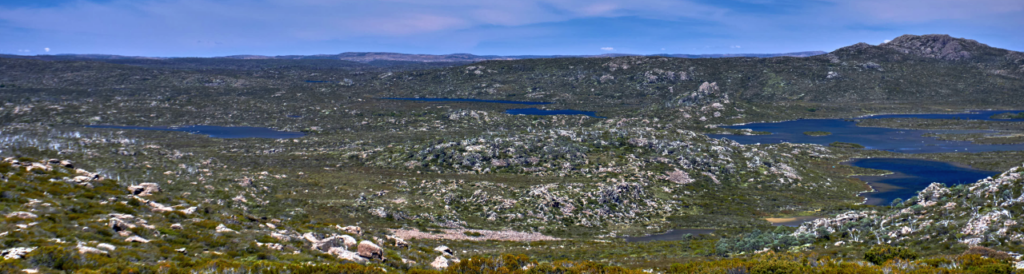
This overnight camping trip will take us past several beautiful highland lakes, with views of many more. It will include the opportunity to climb two easy mountains: Forty Lakes Peak and Little Throne. The walk joins two tracks, Explorer Creek Track and Blue Peaks Track with a short off-track walk. The off-track section is mostly easy, but there is a little light scrub to be pushed through. It is suitable for walkers who have had some experience with off-track alpine walking. Energetic older children should be able to manage this walk.
Walk route:
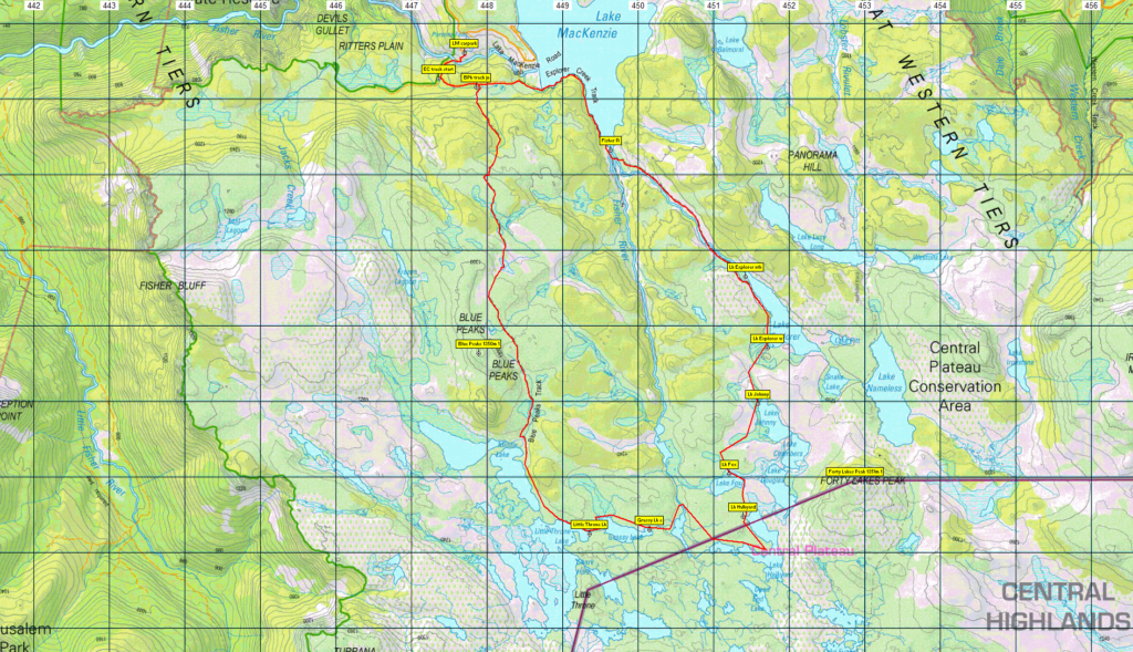
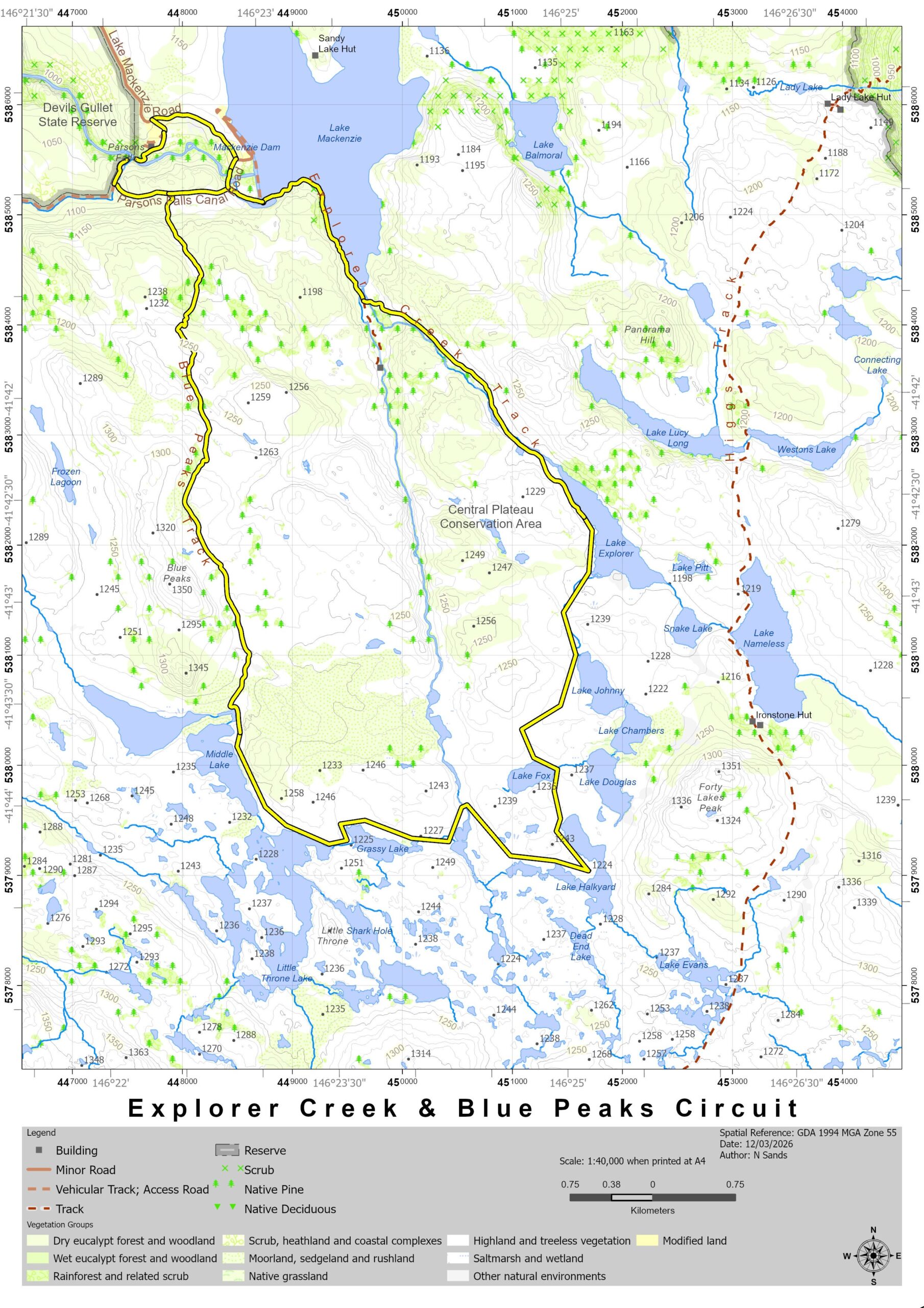
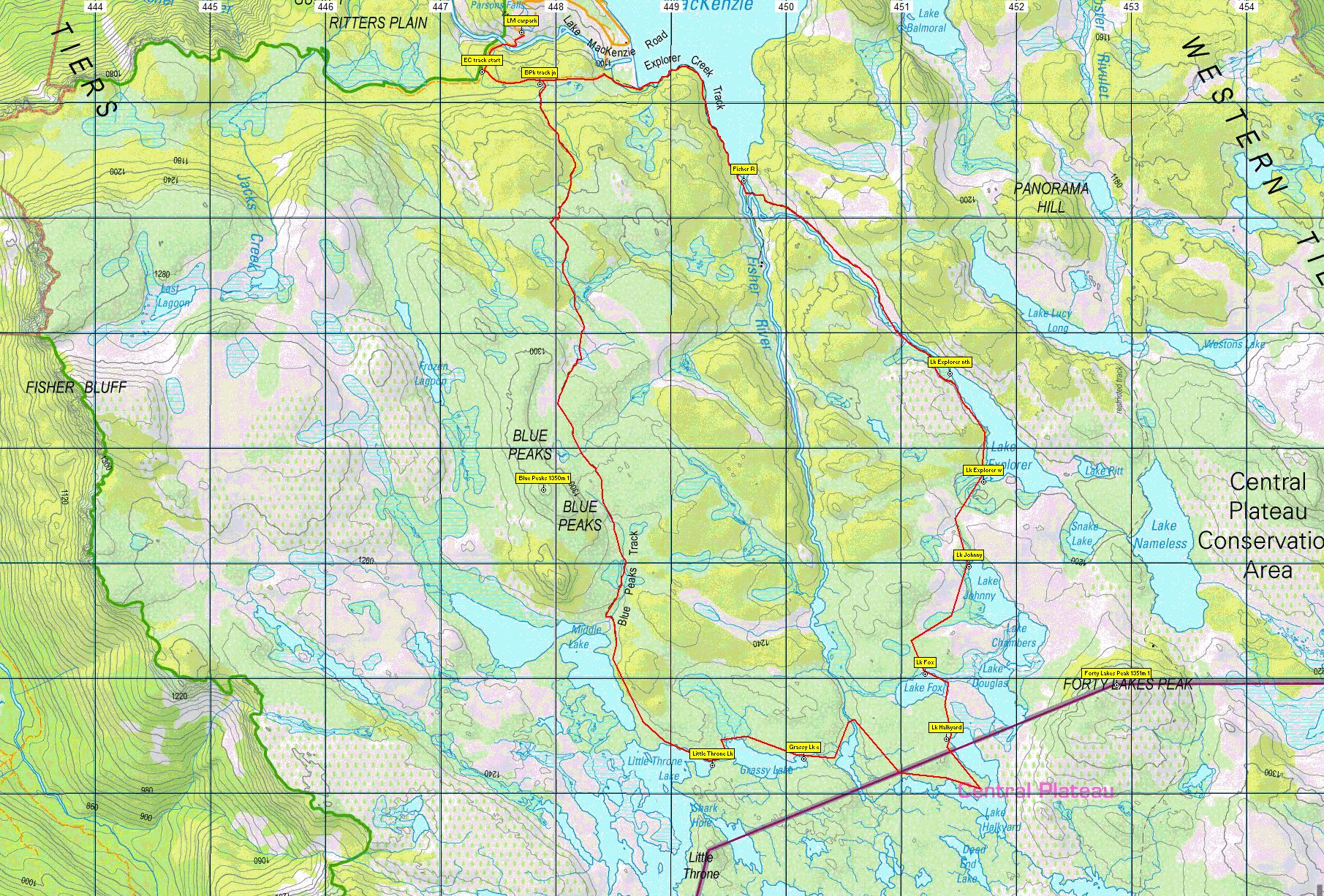
Day 1: From the car park at Lake Mackenzie, already 1100m altitude, we walk around the boom gate, along the road across a bridge and past the southern end of the dam, heading south-east for about 2 km to reach the Little Fisher River. The route crosses the river and continues a further 2 km south-east, following Explorer Creek to reach Lake Explorer. From here we will leave the track which peters out here anyway. We will divert to Lakes Fox and Halkyard where we will camp for the night. If time allows and if walkers are energetic enough, we can climb Forty Lakes Peak and then return to the campsite.
Day 2: The second day will involve continuing off-track west to Grassy Lake, Little Throne Lake, and climbing the tiny mountain, Little Throne. We then walk north to Middle Lake and pick up the Blue Peaks track back to Lake McKenzie. Depending on time and energy, it may be possible to climb the northern high point of Blue Peaks, only 500 metres (+50m alt.) from the track.
Apart from the two mountain climbs, the walk is relatively flat. The track is quite indistinct at times, so it is critical that the party keep together and navigate carefully.
As this is a camping trip, a checklist of essentials is a good idea. Parks and Wildlife Tasmania have a comprehensive Safety in Parks page which covers many aspects of bushwalking safety and equipment, including a Walker Pack List that is well worth a read. However, much of this gear can be shared with a partner – perhaps a more experienced walker who already has some of the big-ticket items such as tent and stove. Make sure you are prepared for wet and cold weather no matter what the forecast is.
Booking Details, Meeting Times and Places:
If you are interested in going on this walk, please phone Nik Sands on 0429 387 777 to book in, preferably by Wednesday night, 15th April, so that cars, tent sharing etc can be arranged. Nik would appreciate hearing from you much earlier, of course. The departure time is 7:30 am from Door of Hope carpark in South Launceston. Meeting points along the way could be 8:00 at the Mole Creek Road roundabout at the western end of Deloraine, 8:20 at Mole Creek or 8.35 at the Lake Mackenzie (Devil’s Gullet) Road junction with the Mersey Forest Road. However, you still need to contact the walk leader per details above if intending to walk. The leader should be notified of any other people you intend to bring along. Please be at any meeting place 5 minutes ahead of departure time.
Online Registration required! Current SU safety regulations require completion of an online registration form for all overnight camping trips. You must still contact Nik, however, to confirm that this is the right walk for you. Click here [link] to register online.
To access this area from northern Tasmania:
From Launceston, proceed along the Bass Highway to Deloraine (about 51 km), but do not turn off at the eastern exit into Deloraine. Instead, continue across Meander R. and up hill to the western exit, and to the roundabout at start of Mole Creek Rd. A further 24km will bring you to Mole Creek. Continue west past Mole Creek, on what is now Liena Rd, making sure you turn south at the caravan park 4 km from the town. The road continues west until about 14 km from Mole Creek, it branches south, now called Mersey Forest Road. A little over 6 km south, you will pass a turnoff to Cradle Mountain and Sheffield, and about 300 metres further, take the turn on left to Devil’s Gullet/Lake Mackenzie. Follow this road about 19 km, and just short of the Lake Mackenzie dam, turn south to find the car park and boom gate from where the walk starts.
Warnings:
The following codes [from our 2026 walks calendar] apply:
D Drive distance requires early departure – usually 7:30 am
L A long day’s walk – in excess of 3 hours each way.
M Marshy or muddy sections be prepared to walk with wet feet.
E…Exposed alpine conditions – can be dangerous in poor weather if not fully equipped.
This walk is above 1100 metres altitude for the whole distance and can be very exposed if the weather is bad, even at this time of year. Be prepared! Walkers should wear sturdy boots due to uneven surfaces. Gaiters recommended due to off-track walking. You should always carry wet weather gear as well as warm clothing in case of sudden weather changes. For equipment guidelines, CLICK HERE.
Map details: Click for map 1 Click for map 2
Lake Explorer general area: 1:100000 map is Tasmap 8114 (Mersey) and 1:25000 map is 4438 (Lake Mackenzie)
Map reference:
Short ref. n/a
Zone Easting Northing Latitude Longitude
55G 4 51 765 53 82 811
Forty Lakes Peak (alt. 1351 m): 1:100000 map is Tasmap 8114 (Mersey) and 1:25000 map is 4437 (Pillans)
Short ref. 527798
Zone Easting Northing Latitude Longitude
55G 4 52 870 53 79 940 -41.73095 146.43330
Little Throne (alt. 1283 m): 1:100000 map is Tasmap 8114 (Mersey) and 1:25000 map is 4437 (Pillans)
Short ref. n/a
Zone Easting Northing Latitude Longitude
55G 4 49 320 53 78 500 -41.74370 146.39049
Blue Peaks (alt. 1350 m): 1:100000 map is Tasmap 8114 (Mersey) and 1:25000 map is 4438 (Lake Mackenzie)
Map reference:
Short ref. 479815
Zone Easting Northing Latitude Longitude
55G 4 47 890 53 81 640 -41.71533 146.37357
For the peakbaggers, there is 1 point up for grabs at Forty Lakes Peak, none for Little Throne, and 1 point for Blue Peaks, if time permits. For explanation of peakbagging, see our new Peakbaggers and Abels page, which has links to various lists of peaks, including Peakbaggers, Abels, Poimenas and others. For really enthusiastic walkers, Phil Andrew’s recently updated Tasmanian Peaks Composite List [link] can be downloaded, which gives a complete smorgasbord of Tasmanian mountains, hills and high places – enough for a lifetime of bushwalking!
For GPX (.gpx) and Google Earth (.kml) versions of the track for this walk: Click here to browse our collection.
Direct links: GPX for this walk … KML for this walk