
Cradle Fagus Appreciation Walk – Sat. 2nd May 2026
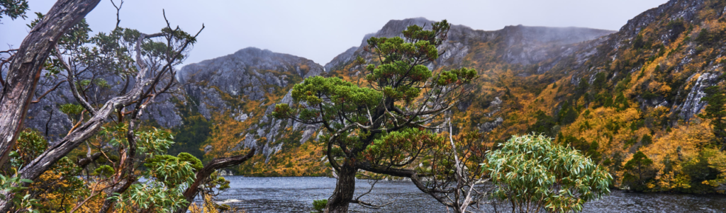
A highlight of the bushwalking year in Tasmania is to enjoy the blazing colour of the “fagus” in the high alpine areas. It has been an annual Boots N’ All tradition for over a decade to have a “Fagus Appreciation Walk” in late April or early May, mostly at Cradle Mountain, but in some years at Grail Falls in the upper Mersey area.
At time of writing, our leader has chosen Cradle Mt, but if the weather forecast is poor, there might be a late change to Grail Falls instead. In that case, the walk will largely follow the outline from last year – see 20250426 Fagus Time – Grail Falls [link]
As usual, we can’t guarantee the weather, or that our planned walk coincides with the peak of the fagus colour, but Cradle is always a special place to visit, so why not join us?
What is Fagus? See https://parks.tas.gov.au/discovery-and-learning/plants/fagus for a great description.
This walk is rated “medium” and is suitable for walkers, including children, who have had some experience with tracks of varying quality – part boardwalk, part steep and rocky path (very uneven and quite demanding in a few places), and able to keep going for sustained distances. Because of the exposed alpine conditions, walkers must be fully prepared for poor weather. Please see the warnings and equipment suggestion link below.
Walk Route:
Private vehicle access to Ronny Creek and Dove Lake is very restricted, so we will likely catch the shuttle bus from the Visitor Centre. The route on the day will begin from either Dove Lake or Ronny Creek. If beginning from Ronny Creek (alt. 870m), the likely route is via Crater Lake to Marion’s Lookout. Grades are somewhat gentler, with some steep pinches, but slightly more altitude to gain, and about 1.7 km longer than the alternative route from Dove Lake (alt. 940m), which skirts around the western shore of the lake for about 1 km before rising very steeply to the west over the next km to reach Marions Lookout (1180m). The track continues south for the next 2 km over a relatively level and open alpine plateau to Kitchen Hut (alt. 1230m). From there, the Face Track branches off to the east, sidling and declining around the northern ridges of Cradle Mountain and Little Horn. After 1.5 km, the Lake Wilks track is followed down a steep descent to Lake Wilks, and then north to meet the Dove Lake Circuit Track which will be followed either north (shorter but a little harder) or east, then north, to reach the Dove Lake carpark. The actual route on the day will depend on weather conditions and the size and capability of the party.
Meeting Times and Places:
If you are interested in going on this walk, please phone your walk leader, Phil Dawson email pidasms@gmail.com or ph. 6382 3561 after 6:30 pm to book in. The departure time is 7:00 am from the Door of Hope Church car park, Launceston. Suggested meeting places if coming from elsewhere could be Sheffield at Claude Rd. turnoff at 7:50 am or Moina at 8:20 am. The group should arrive at the Visitor Centre by approx. 8:35 am. If you would like to arrange to meet the group at these places or elsewhere, please arrange with the leader, and please be at any meeting place 5 minutes ahead of the listed time. The leader must be notified of any other people you intend to bring along.
To access this area from northern Tasmania: Roads to Cradle Mt. are well signposted, and the area can be accessed from several directions. From Sheffield, go south along Claude Rd (C136) through Gowrie Park and westward down into the Forth Valley (now Cethana Rd. but still C136), continuing up the other side to Moina. Turn south into Cradle Mt. Rd. (C123). After approx. 20 km, you will reach the Cradle Mt. turnoff. Turn left (still called Cradle Mt. Rd.) and 3 km south, the Visitor Centre and shuttle bus terminus are on the left.
Warnings:
The following codes [from our 2026 walks calendar] apply:
D Drive distance requires early departure
M Marshy or muddy sections – be prepared to walk with wet feet.
S Steep incline for at least part of the way
E Exposed alpine conditions ; can be dangerous in poor weather if not adequately equipped;
For equipment and safety guidelines, Click Here, especially regarding preparation for exposed alpine conditions.
Map details:
Waldheim/Dove Lake/Cradle Mt area: 1:100000 map is Sophia and 1:25000 map is Cradle.
Map reference: 126845 (Cradle Mountain)
Zone Easting Northing Latitude Longitude
55G 4 12 730 53 84 690 -41.68478 145.95140
No peakbagger peaks will be visited during this walk, although there are 3 in the close vicinity. For explanation of peakbagging, see our new Peakbaggers and Abels page, which has links to various lists of peaks, including Peakbaggers, Abels, Poimenas and others. For really enthusiastic walkers, Phil Andrew’s recently updated Tasmanian Peaks Composite List [link] can be downloaded, which gives a complete smorgasbord of Tasmanian mountains, hills and high places – enough for a lifetime of bushwalking!
Direct links: right-click here to download GPX for this walk or here to open KML for this walk in Google Earth (if available on your device).
To see the full listing of our extensive GPX and KML files, click here. To find one in a hurry, Ctrl-F to bring up a search box, and type in part of the name of the walk. For some walks, there will be more than one version. Right-click on the file and save target as to a location of your choice.
Click here to learn about using your phone as a navigation device, or to find out about handheld GPS devices.
