Fortescue & Tasman Capes camping 6-8 June 2026
The Tasman Peninsula is located in the southeast and is well known for bushwalking, camping and diving and has increased in popularity due to the development of the Three Capes Track. This weekend will offer a variation of the Three Capes Track with the opportunity to visit two of the capes – Cape Hauy and Cape Raoul.
We’ll camp at Fortescue Bay and do both of these as day walks. There will also be ample opportunity to spend on the beach, as well as other shorter walks within the area. If you would like to come on this trip, but are unsure of the walks, particularly the ability to go up and down many steps, then you are more than welcome to stay at the beach or undertake other shorter walks in the area. Don’t let the steps stop you from enjoying this stunning location! Being a sheltered coastal location, weather is often milder and drier than other parts of the state, even in early winter, and whales might be seen on their migration north at this time of the year.
Minimum number: To confirm the viability of this walk, Hannah would want a minimum of 4 participants, so please contact her as soon as possible to allow her to ‘lock in’ the adventure.
Camping Information:
The campsites, which are suitable for tents and swags, will cost $5pp per night. Booking isn’t needed in June. There is an option to stay in a campervan or similar (your own…) at Fortescue Bay. Please check the linked website for information about sites for campervans or similar.
Even though it is winter, be aware that it will be a long weekend, so there will be other users, but it is unlikely to be crowded.
The campsite provides drinking water, toilets, showers (token to be purchased from PWS office) and gas BBQ’s.
The PWS website contains all of the information about Camping at Fortescue Bay [link].
Gear to take includes: cooking equipment (stove, pots/pans etc), crockery and cutlery, food (there is no fridge, but eskis are often sufficient for a couple of days), camping equipment (tent, sleeping mat, sleeping bag, pillow).
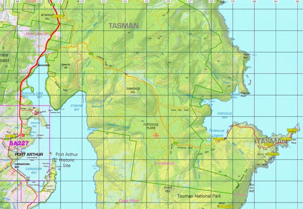
Saturday 6th – Launceston to Fortescue Bay; Cape Hauy
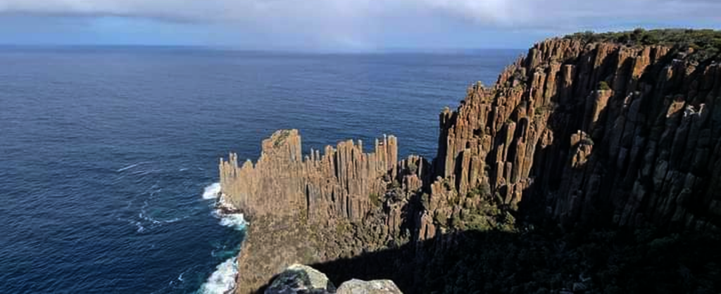
We will leave Launceston at approximately 8am, with a 3.5 hour drive to Fortescue Bay. After setting up our campsite, we will head off to Cape Hauy. Cape Hauy is an absolutely stunning walk that showcases the sheer dolerite cliffs that the Tasman Peninsula is known for. This track is quite undulating, which has resulted in around 2000 steps each way. The return trip will be 9.4km, taking about 4 hours.
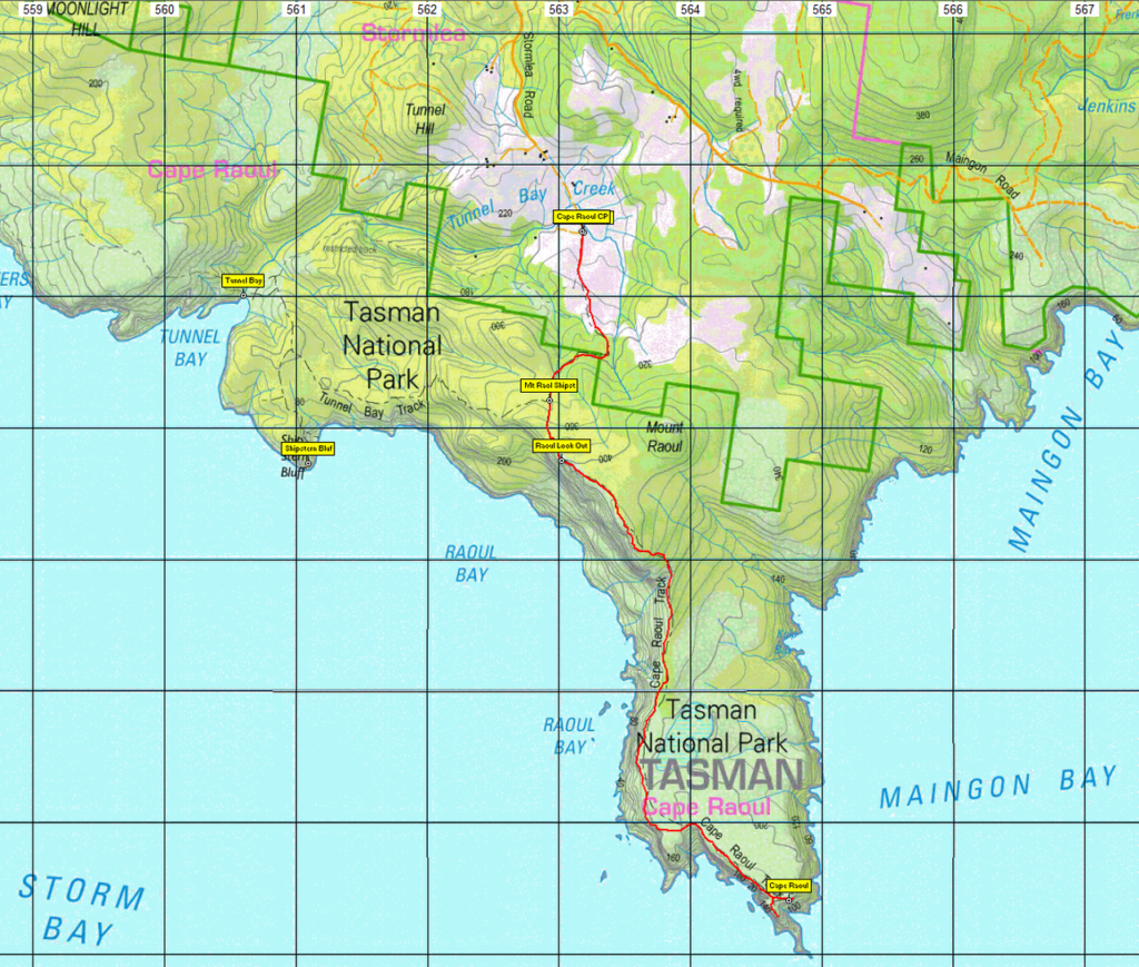
Sunday 7th – Cape Raoul
Today we’ll jump back in the car and drive around to the Cape Raoul walking track. This walk starts amongst inland heath and heads towards the coast and back to those jaw dropping sea cliffs. This track traverses similar terrain as Cape Hauy, however does not have quite as many steps. The return trip will be 14km, taking about 5 hours.
Monday 8th – Fortescue Bay to Launceston
After packing up the campsite, the morning will be free for another activity. There will be the options of staying at the beach, finding another one of the many other walking tracks, or perhaps visiting the nearby Port Arthur or going on a Pennicott Cruise. Please note that both Port Arthur and the cruise will have an additional cost, and the cruise will need to be booked in advance. We will aim to leave the Peninsula around lunch time, in order to return to Launceston by mid-afternoon.
Meeting Times and Places:
If you are interested in going on this walk, please phone Hannah Waterhouse on 0427 026 233. Early expressions of interest are encouraged!
The departure time is 8am from Door of Hope carpark in South Launceston. Additional meeting points can be arranged if needed. The leader should be notified of any other people you intend to bring along. Please be at any meeting place 10 minutes ahead of departure time.
Important! Online Registration is required for this walk! SU safety regulations require completion of an online registration form for all Boots N’ All overnight camping trips. Registration link will be here by mid-May.
Hannah would very much appreciate hearing from you as soon as possible to help her confirm numbers – even if you are not absolutely certain you will attend.
To access this area from northern Tasmania: From Launceston, follow the southern outlet and Midland Highway (A1) for 128 km to reach the junction of Mud Walls Rd. Turn left into Mud Walls Rd (B31) and continue for 36 km through Colebrook to Campania, then continue another 2.5 km to reach Fingerpost Rd. Turn left into Fingerpost Rd (C350). Continue just over 7 km to reach Tasman Highway (A3) Turn right and continue 9.5km south to reach Sorell. Continue straight ahead into Arthur Highway (A9). Follow the Arthur Highway for 63 km via Copping, Dunalley, Murdunna, Eaglehawk Neck and Taranna to reach Fortescue Bay Rd (Joiners Link) (C344) and turn left. Follow Fortescue Bay Rd for 12km to reach Fortescue Bay and the campground. Allow 3 hours 10 minutes (plus any breaks) from Launceston.
Warnings:
The following codes [from our 2026 walks calendar] apply:
S Steep incline for at least part of the way
L A long day’s walk – in excess of 3 hours each way.
Walkers should wear sturdy footwear due to uneven surfaces. Carry plenty of water and a snack, and lunch for the longest walk. You should always carry wet weather gear as well as warm clothing in case of sudden weather changes. For equipment guidelines, Click Here
No peakbagger points will be visited during this walk. Mt. Fortescue (1 point) would be an 8 km (return) side trip from the Cape Hauy walk. For explanation of peakbagging, see our new Peakbaggers and Abels page, which has links to various lists of peaks, including Peakbaggers, Abels, Poimenas and others. For really enthusiastic walkers, Phil Andrew’s recently updated Tasmanian Peaks Composite List [link] can be downloaded, which gives a complete smorgasbord of Tasmanian mountains, hills and high places – enough for a lifetime of bushwalking!
For GPX (.gpx) and Google Earth (.kml) versions of the track for this walk: Click here to browse our collection.
Direct links: GPX for this walk … KML for this walk
Right-click on the file and save target as to a location of your choice. (Suggest you click the Last modified at top to sort by date to get the most recent at top to find the file for the next walk).