Meander Falls Sat. 30th May 2026
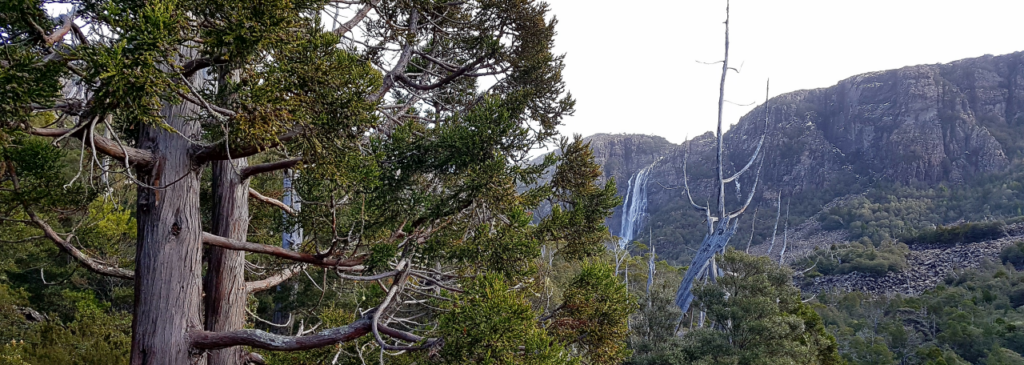
With the days nearing their shortest, autumn rains and heavy frosts, Meander Falls at this time of year will hopefully be in strong flow, or even a frozen wonder, as they were when Boots N’ All went there 8 years ago. Either way, they are well worth a visit.
This walk is of special significance, being the 45th anniversary of the first ever Boots N’ All walk on 30th May 1981. That walk was led by Ken Macpherson who went home to the Lord in late March this year.
Walk Notes:
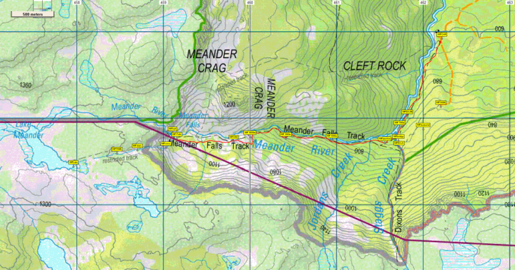
From the car park (altitude 600m), the track, following the course of the Meander River, heads south for 1.5 km before continuing west for a further 3 km. During this time, the track climbs steeply for much of the distance, reaching 1100 metres altitude by the time the base of the falls is reached. Some further clambering to the middle of the falls might be possible. Return will be by the same route for the first 2.5 km, then perhaps a detour to a slightly higher track that goes past the base of Dixon’s Track and a memorial to two bushwalkers who died in the area some years ago, finishing on an old logging road back to the car park.
Even though the distance is only 7km return, the walk is rated medium-hard due to the steep and at times rough nature of the track, the short daylight hours and the possibility of cold and wet conditions. It should be suitable for energetic, resilient and experienced older children, but please consult with walk leader.
Meeting Times and Places:
If you are interested in going on this walk, please phone or message Grace Hillman on 0490 840 866. The departure time is 8:00 am from Door of Hope car park. Alternative meeting place: Deloraine 8:30 am. Check with leader for meeting spot. If you wish to meet with the group at any other place, please arrange with the leader. However, you still need to contact the walk leader, if intending to walk. The leader should be notified of any other people you intend to bring along. Please be at any meeting place 5 minutes ahead of departure time.
To access this area from northern Tasmania: From Launceston, head towards Deloraine on the Bass Highway (50 km) and take the first (eastern) turn from the highway into Deloraine. Continue into the town and turn left immediately before the bridge (meeting place – see above).
From Deloraine, head south along the “Lake Highway” – now Highland Lakes Rd. (but the first bit may be called Meander Rd!). Make sure you stay on Meander Rd and go straight ahead (DON’T turn left) at 7 km from Deloraine, where there is a signposted junction for Highland Lakes Rd. Continue a further 9 km to Meander and continue through the town. After about 6 km, the road swings right. About 2.5 km further, the road turns south and crosses the first of the new bridges (Smoko Creek), followed shortly by the 2nd bridge which takes you across the Meander R. Less than 3 km further, you will reach the Meander Falls car park and the beginning of the walking track.
Warnings:
The following codes [from our 2026 walks calendar] apply:
S Steep incline for at least part of the way
M Marshy or muddy sections be prepared to walk with wet feet.
E Exposed alpine conditions ; can be dangerous in poor weather if not adequately equipped.
Walkers are advised to wear strong shoes or boots. You should always carry wet weather gear as well as warm clothing including gloves and beanies in case of sudden weather changes. The destination of this walk is above 1000 metres altitude, and can be very exposed if the weather turns bad. Be prepared!
Winter bushwalking can be dangerous in poor weather if not adequately equipped; see http://bootsnall.sutas.org.au/Pages/Equipment_Safety.htm for some guidelines.
Map details for Meander Falls area:
1:100000 map is Meander (Tasmap 8214) and 1:25000 map is Pillans (Tasmap 4437)
Map references:
Short ref. n/a
Meander Falls:
Zone Easting Northing
55G 4 59 098 53 79 784
No peakbagger points will be visited during this walk. For explanation of peakbagging, see our new Peakbaggers and Abels page, which has links to various lists of peaks, including Peakbaggers, Abels, Poimenas and others. For really enthusiastic walkers, Phil Andrew’s recently updated Tasmanian Peaks Composite List [link] can be downloaded, which gives a complete smorgasbord of Tasmanian mountains, hills and high places – enough for a lifetime of bushwalking!
For GPX (.gpx) and Google Earth (.kml) versions of the track for this walk: Click here to browse our collection.
Direct links: GPX for this walk … KML for this walk