Hidden Falls Circuit – Sat. 11th July 2026
It might be the dead of winter, but the foothills of the Western Tiers are usually a great place to explore, with plenty of water in the rivers and cascades. Phil will again lead us to Hidden Falls in the upper Meander area.
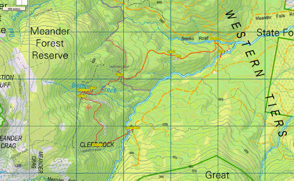
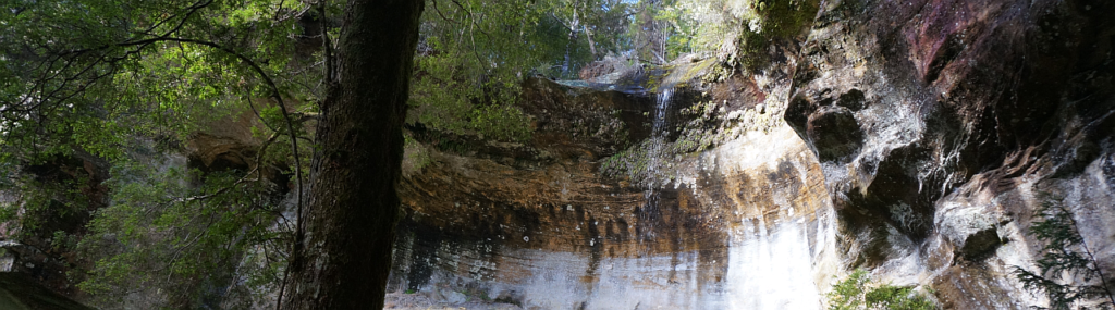
Hidden Falls is a surprising and spectacular feature less than 200 metres from the better-known Bastion Cascades, which will also be visited. The walk starts at an old quarry at 580 metres altitude, and rises west and then south-west, contouring around into the valley of Bastion Creek at about 700m altitude, to reach the cascades after about 2.5 km walk from the start. Doubling back a couple of hundred metres, the track then rises steeply and sidles around to the top of the cascades, from which the creek is crossed and Hidden Falls, less than 150 metres south, is reached after a steep rise through the forest.
From there, the route will contour south about 1.5 km around the foothills of Meander Crag to meet the Split Rock (aka Cleft Rock) track, then downhill east to the Meander River at the Meander Falls car park. As this is 2.5km by road from the walk start, a car shuttle will be necessary. The walk is rated “medium” due to the steep grades and likely untracked sections, and is suitable for reasonably fit and suitably equipped walkers familiar with wilderness forest walking. Energetic older (accompanied) children should cope with this walk which is approximately 7 km in total.
Meeting Times and Places:
If you are interested in going on this walk, please call walk leader, Phil Dawson email pidasms@gmail.com or ph. 6382 3561 after 6:30 pm to book in. The departure time is 8:00am from the Door of Hope Church car park. The alternative meeting place/time is Deloraine at 8:30 am. (Turn onto the Lake Highway at junction in Deloraine on Launceston side of bridge over Meander R.)
Please be at any meeting place 5 minutes ahead of departure time. However, you still need to contact the walk leader, if intending to walk. The leader should be notified of any other people you intend to bring along. Please be at any meeting place 5 minutes ahead of departure time.
To access this area from northern Tasmania: From Launceston, head towards Deloraine on the Bass Highway (50 km) and take the first (eastern) turn from the highway into Deloraine. Continue into the town and turn left immediately before the bridge (meeting place – see above).
From Deloraine, head south along the “Lake Highway” – now Highland Lakes Rd. (A5) (but the first bit may be called Meander Rd!). Make sure to stay on Meander Rd and go straight ahead (DON’T turn left) at 7 km from Deloraine, where there is a signposted junction for Highland Lakes Rd. You are now on C187. Continue a further 9 km to Meander and continue through the town. Continue a further 9 km to Meander and continue through the town. After about 6 km, the road swings right and is now Meander Falls Rd. About 2.5 km further, the road turns south and crosses the first of 2 quite modern bridges (Smoko Creek). Just across this bridge, turn off to the right and follow the fairly steep road for about 1 km to reach the old quarry from which the walk starts.
The walk will end at the Meander Falls carpark which is just under 3 km further past the Smoko Creek bridge, hence the car shuttle
Warnings:
Rated Medium because of the steep inclines and off-track walking in places. The following codes [from our 2026 walks calendar] apply:
S Steep incline for at least part of the way
M Marshy or muddy sections be prepared to walk with wet feet.
E Exposed alpine conditions ; can be dangerous in poor weather if not adequately equipped.
Walkers are advised to wear strong shoes or boots. Gaiters give extra protection in the expected conditions. You should always carry wet weather gear as well as warm clothing in case of sudden weather changes, especially in winter.
Winter bushwalking can be dangerous in poor weather if not adequately equipped; Click Here for some guidelines.
Map details: 1:100000 map is Meander (Tasmap 8214) and 1:25000 map is Quamby Bluff (Tasmap 4638)
Map reference:
Short ref. is n/a
Zone Easting Northing Latitude Longitude
n/a
No peakbagger points will be visited during this walk. For explanation of peakbagging, see our new Peakbaggers and Abels page, which has links to various lists of peaks, including Peakbaggers, Abels, Poimenas and others. For really enthusiastic walkers, Phil Andrew’s recently updated Tasmanian Peaks Composite List [link] can be downloaded, which gives a complete smorgasbord of Tasmanian mountains, hills and high places – enough for a lifetime of bushwalking!
For GPX (.gpx) and Google Earth (.kml) versions of the track for this walk: Click here to browse our collection.
Direct links: GPX for this walk … KML for this walk